It was back to Sperryville for an almost repeat of Friday’s ride. It was cool, perhaps 68°. I headed off and only went 200 yards and thought I might need a jacket. I went back to the car. I wasn’t worried about climbing as I knew my body heat would be enough. It was the descent I worried about as I didn’t want to get too cool.
I headed off a second time. I had gone just 200 yards and realized I didn’t have my heart monitor. I am learning to play with my Garmin Edge 705 and the heart rate monitor is part of it. I want to see what my body was doing as I was climbing. Back to the car.
The third time was a charm. I headed out for the seven-mile climb to the top. The first two to three miles are at two percent grade before the road turns up.
On Friday I never went lower than my 4th sprocket so I figured I had to match that today as well. That has 19 teeth and I can go to my lowest gear which has 27 teeth. I am hoping that what the run-up to Skyline Drive lacks in grade (6-7% mostly) that going in a higher gear will offset.
I’m hoping.
Unlike Friday I didn’t have water running down the road at me and thunder and lightning near me. There were no weather distractions so one could think about the ride up the mountain.
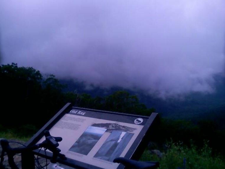
Supposed to be a view of Old Rag Mountain from here
As I crested the top a motorcyclist passing in the other direction gave me a huge thumbs up. It is nice to be recognized.
I switched into the big ring for my ride down the mountain to Luray. Technically I didn’t go all the way to Luray. Although I was prepared to when the road passed the National Park Headquarters it flattened out to a four-lane divided highway with a speed limit of 55 mph. I didn’t need that. I came to climb, not ride another mile or two of flat roads, so I turned around and began my climb back to the summit.
This one was a four-mile climb. I didn’t have any difficulty but there were times I wanted to switch to a lower gear than 19 teeth. But I didn’t.
I reached the summit then paid $8.00 to ride on the Skyline Drive. I wanted to go south at least as far as the tunnel which came in a mile or a mile and a half. It was very foggy here and I had no lights on me. I was worried about being seen in the tunnel but I went. No cars came behind me while I was in the tunnel.
As with much of my riding, my new goal became to ride until the road turns downward. That would be about five miles by my estimate. I just kept climbing. When I finally reached the high point, I turned around for the crazy descent back to Earth.
I love roller coasters but the thrill of descending at high speeds, around corners and just straight away on a bike is better than ANY coaster I have ever been on. This is the WEEEEEEEE! moment that makes climbing pays off.
In short order, I was back to the Skyline Drive entrance and then back on U.S. 211 East to Sperryville. Although I had cars behind me, no one caught me until I had descended four miles and the road flattened out a bit.
It was a great ride. My Garmin unit measured my distance and 32.5 miles over 4,200 hundred vertical feet of climbing.
In preparation for Mt. Washington, I will not find an 8 mile 12% grade climb with 40 mph winds and near-zero visibility. So one must train under lesser conditions.
My Independence Day route took me to Sperryville, in Rappahannock Co., Virginia. Just as I arrived it started raining. I didn’t want to ride up the mountain in the rain and hoped to wait it out. I listened to WTOP news and their weather forecast described a storm over Rappahannock Co. which would be breaking up soon. As soon as the rain stopped I started up the mountain.
From Sperryville, it would be a seven-mile climb to the summit although the first two miles would be only a two percent grade or so. I started up the mountain. After the first two miles, it started raining. I didn’t avoid it after all but at least it was a light rain.
Until the road reaches Shenandoah National Park it is a two-lane road with no shoulder. I noticed the cars with cargo on their roof racks tended to give me a wide berth while vehicles without cargo often didn’t move out of the lane even when no opposing traffic was coming. I figured the tourists were more understanding than locals of cyclists on this road. Maybe I was wrong but it is what I thought.
Once in the park, the road widens to three lanes — two in the up direction so faster drivers can pass those in the slow lane.
There was one courteous driver who passed. He was the driver of an 18-wheeler and my only thought was why an 18-wheeler was even on this road. But I was on the “shoulder” at that point which was about six inches to the right of the road. I heard him behind me and noticed he wasn’t going to pass even though he could. He waited until there was no opposing traffic. I gave him a high wave when I heard his engine rev to thank him for waiting until there was more room to pass. He responded with a quick but light reply on his air horn.
I was tapping out a good rhythm and saw a sign that Skyline Drive was two miles away. Then I heard a loud clap of thunder. I hoped not to see lightning. My glasses were keeping the rain out of my eyes but were fogging up a bit. I thought I saw a flash but wasn’t sure. But then, I was sure.
There was thunder and lightning all around. I know the safest place on a bike during an electrical storm is not on a bike. If there was an opening one could lay down the bike and sit low away from any trees. But I was in a forest. My choices were to keep going or to turn around. I had come too far to turn around and I thought I might get through the storm quicker by going through it. I continued climbing.
The rain was coming down very hard. The gullies next to the road were running full and flowing across the road. At times I was battling not only gravity but currents too. I continued.
The heaviest part of the storm did not last long, no more than 10 minutes. I was soaked. I wondered what the few riders who passed me thought. I alternated my pedaling in and out of the saddle.
On my rear 10-speed cassette, I knew I wasn’t in my low gear. And that became intentional. I reasoned that if I am going to climb Mt. Washington I have to make lesser climbs a bit harder. Not using all my gears was part of my plan.
Unlike mountain or hybrid bikes, there is no click shifting with gear numbers on my road bike. It’s all done by feel and if one must know, a quick glance back to see where the chain is on the gears.
I approached the summit and the pedaling became easier. I had made it. I biked over the summit to Page Co., and then stopped to check out my gearing. I wasn’t even in my second gear. Or third. I had climbed to the summit of Skyline Drive in my fourth sprocket which gave me a great feeling about my fitness level for next weekend.
I turned around for the reward — a fast descent back down to Sperryville on wet roads.
I was up early at my parent’s house in Friedens and decided to ride some more in the mountains. I drove to Jennerstown and parked on Main Street. I rode the mile or so out of town then the steep descent on U.S. Rte 30. After a quarter-mile drop, one is at the lowest point before the climb.
The Tour of Pennsylvania described this as a two-mile climb with a very intense mountain pass that sees grades of 15%. I had no problem going right up the mountain although not as fast as the boys did on Friday. I wanted to go over the top back to Laughingtown then come back up and over but the sky looked ominous. It looked like a storm was about to move into these mountains and I didn’t want to get caught in it. I turned around at the truck area and headed back to Jennerstown. I was disappointed that I never got above 45 mph on this descent.
I thought about driving over to Rector and going up, then down, Darlington Road again but wasn’t sure where the storm was and wanted to try something new. I drove to Altoona.
I had remembered an article Bicycling about the toughest 100 climbs in the U.S. One of those was the Horseshoe Curve climb in Altoona. I parked on 58th Street and started out towards Kittanning Point Road. The climb was up, past three reservoirs, but never very tough. As I climbed I heard a train creaking and breaking as it descended the Allegheny Mountains towards Altoona. It was way too easy that I reached Horseshoe Curve. I couldn’t believe this was a tough climb. It wasn’t.
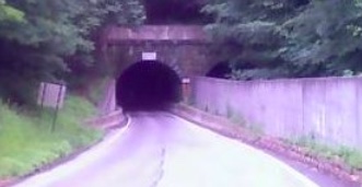
I saw a tunnel and went through it under the Horseshoe Curve. On the other side was a beautiful forested country road. I kept riding and it kept going up. And that was the new deal I made with myself. As long as the road turned up, I would keep riding.
Tunnel at Horseshoe Curve
I saw a sign for Adopt a Highway and saw it was sponsored by Blair Co. Bicycle Club for the next four miles. I figured I had four miles. Cool.
After about three more miles I was getting tired. I was in my granny gear and was standing and sweating. But I kept moving without “paperboying” back and forth across the road to make the grade a little easier. Finally, it became easier.
I read later that this section is 10-12% but then one hits the wall at a 19% grade for a half mile before settling back to 12% for the last mile. That was it. And I made it. I love riding in these mountains.
I turned around. On the descent, I wanted to let it out. But this road had many curves and it was raining. The rain was following me. The last speed I saw was 43 mph in a curve. Then my computer went out. On the transmitter, a support broke off so it wasn’t in the right position to read the magnet on the spoke. I was doing 0 then 10 then 6 then 4 then 38.
I will need to come back and explore this more. Much more. It was everything as advertised especially “three lakes and a 200′ tunnel.” It is absolutely beautiful.
Stage 5: Ligonier to Pittsburgh (Saturday, June 28, 2008) (Start time: 12 noon) This 83-mile stage will give the riders a more subdued ride as they enter into downtown Pittsburgh. The route will follow a mostly rolling course with one short KOM at mile 21 and one last intermediate sprint at mile 38 on the outskirts of Latrobe. The race will continue towards Pittsburgh with a sprint finish at the headquarters of title sponsor American Eagle Outfitters. Spectators should be prepared for a thrilling, four-corner downtown sprint finish.
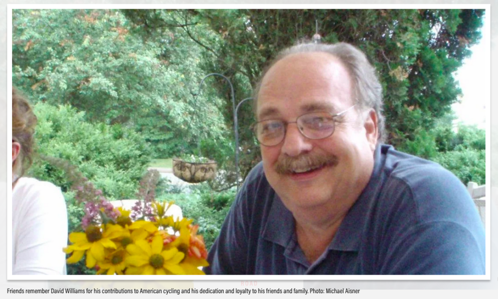
I rode early in the morning and then went to the Diamond at 10:00 a.m. Dave “Lumpy” Williams thanked the volunteers and “without insulting the volunteers who came from other towns” opined that Ligonier was the prettiest town on the tour. I would agree. When Lumpy welcomed us he deadpanned the title, “The American Eagle Outfitters’ Tour of Pennsylvania presented by Highmark Healthy High 5,” stopping to raise his hand in the air to simulate giving a “High 5.”
Whereas in Bedford the volunteers were assigned to a location in town, this race was to start by the Fort just below the Diamond then head out of town on Rte 711. All our assignments were out 711 all the way to Donegal. I knew the location I wanted was the intersection with Darlington Road but when it was offered as the “unmarked four-way intersection” everyone just looked at each other then one person said he would find it. Only later did I realize which intersection it was – the one I wanted.
Still, it all worked out. I got to bike out past Stahlstown to Fort Hill Road, 10 miles exactly, mostly uphill. As I rode some locals thought I was leading the race and were cheering for me. But when asked I always stopped and told them what real racers looked like. “Young,” I told them.
I reached Fort Hill Road and rested my bike against a sign. There was a young mother, no older than 30, on an ATV with two small kids in a field across the road. I went to talk with them and told them how exciting it was to watch a race, especially with all the police cars and motorcycles. I was able to explain to them what they would see. Basically, a parade of cars, led out by state policemen, would be coming up the road. Media. Race referee. Then riders followed by team cars, doctor or ambulance, and the dreaded broom wagon.
Since we were at the bottom of a hill, the racers flew by in a matter of 3-4 seconds. And that was it. Pretty exciting, no?
I said goodbye, the family thanked me for explaining to them what the bike race was, and I headed back to Ligonier. As I left I saw the road was blocked and an ambulance was tending to someone in the ditch. The “broom wagon” had gone by with the caravan but had doubled back so we know some rider was done for the tour.
(Two riders, Alex Welch and Nathaniel English, were listed as Did Not Finish on this stage. Likely it was one of them.)
This morning I arrived in Ligonier and parked in front of my brother’s house although he was out of town. I rode back down to Carey School Road and climbed it again. It is steep and was a good climb for me. Again, like yesterday, my descent was 45 mph. I did a loop around the west end of town and then cut through the school parking lot again back to Carey School Road. This time when I reached the top I pedaled full out. I reached 46.5 mph which was a personal best on my bike.
I went to the Diamond at 10:00 a.m. to meet up with all the volunteers. Assignments were handed out and at first, I was disappointed it was so far out (10 miles) but I knew it gave me a chance to bike and not drive. It was mostly uphill out to Stahlstown which gave me a chance to pass my fellow volunteers who had been stationed at every intersection along Rte 711 and had driven to their assignments.
My return to Ligonier could have been a 10-mile run-in on Rte 711 but when I came to Darlington Road to Rector I decided to go down the road I went up the day before. The road is scary steep.
It was 1970 or 1971 that my brother, Brad, was on this hill on his bike. I can’t imagine that he was far up the road because no one would venture that high. But he was on a bike, just 10 or 11 years old, and on his descent, he hit some gravel at the bottom of the hill where the bridge crosses Loyalhanna Creek and crashed hard. He chipped a front tooth and was generally messed up.
This was in the back of my mind as to whether I even wanted to go down this road, let alone fly down this road. I approached the top of the hill, which is flat, with trepidation. I looked behind me and a car was coming up on me. My thought turned to the car as to whether or not he would try to pass on this narrow country road that went straight down. That would be no problem.
I pedaled, though not hard at first. My speed went from 20 to 25 and then to 30. I looked back and the car was farther back. My speed was 35 then 40. I was headed down and was pedaling even harder. The speed was 45 then 46.5. I last saw it at 49 but couldn’t risk looking at the speedometer. I had to watch the road and worry about the bridge where Brad wiped out.
I finally just got in a tuck and let it roll. This was a combination of adrenaline rush and excitement mixed with pure terror. In other words, it was great! I flew across the bridge and as I was rolling on a slight uphill, looked down to view my high speed. It was 49.8. I guess I can round it to 50 mph! (I didn’t.) That was a personal best.
I then casually rode Rte 381 back to Rte 30 then took Old Rte 30 back into town. I wasn’t sure if or where to ride next.
I drove out Rte 30 headed back to my parents in Somerset and came to Laughlingtown. And I thought, “Why not?”
I parked and got my bike out and decided I would ride up Laurel Mountain from Laughlintown. The distance to the summit is 3.5 miles and the signs at the top warn of an 8% descent. I hadn’t biked far this day, only 20-25 miles, but wondered how my legs would be on a 4-mile climb. Basically, they did fine. I made it with no problems and no stopping. I was disappointed in my descent. My speed was only 40-45 mph which was the posted speed limit. I bet the Tour riders on Friday were 10 mph faster.
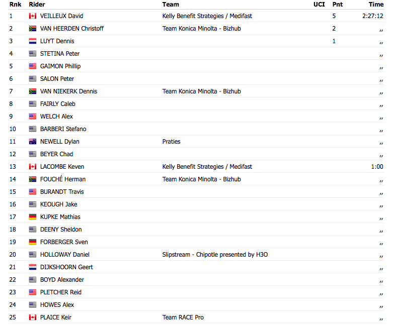
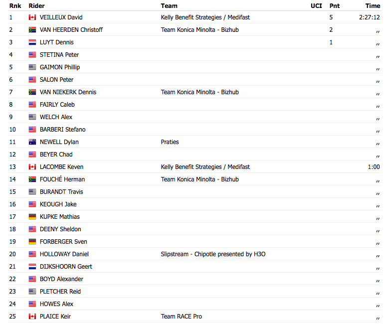
As far as the race: The American Eagle Outfitters Tour of Pennsylvania presented by Highmark Healthy High 5 neared its end as the international U25 field entered onto the Pittsburgh streets in the race’s penultimate stage five. The peloton began what was considered an early sprint in pursuit of a break of six riders that cleared the peloton mid-race. The finishing circuits showcased Pittsburgh’s newly built shopping district before an exciting finish outside of the American Eagle Outfitters world headquarters. The pair of French-Canadians, David Veilleux and Keven LaCombe (Kelley Benefit Strategies-Medifast), shocked the Pittsburgh crowds when they emerged out of the final bend with a sizeable lead over one remaining rider from the original breakaway, American Phil Gaimon (Fiordifrutta). “It feels great to have the leaders jersey and this was our plan since our meeting in the morning,” admitted stage winner, Overall Race leader and Best Sprinter leader, David Veilleux. “We planned to have Keven and I jump together and surprise everyone in the last part of the circuits.” Both Veilleux and LaCombe crossed the victory line together, applauding one another for their cagey tactics that moved Veilleux into the American Eagle Outfitters yellow leaders jersey, two seconds ahead of the previous leader from South Africa, Christoff Van Heerden (Konica Minolta) and American Stefano Barberi (Z-Team). The 91-mile stage gave the international U-25 field a more subdued ride as they entered into the City of Pittsburgh.
The route followed a mostly rolling course with one short VisitPA.com KOM around mile 22, made obsolete by the event’s leading climber from Boulder, Colo., Peter Stetina (VMG-Felt) who solidified his lead of the climber’s competition during the previous stage. The early miles also presented the sprinter with one last intermediate hot spot at mile 37, on the outskirts of Latrobe. American Chance Nobel (California Giant Berry Farms) scooped up the full points during his solo breakaway that gained nearly two minutes on the field. A second breakaway of three riders let loose on the second half of the stage to include Australian Forbes Trail Most Aggressive Rider Dylan Newell (Praties), the Belgian Steven Van Vooren (Johan Brunyeel Cycling Academy) and South African Travis Allen (Konica Minolta). The trio was later joined by three more Americans, Sheldon Deeny (Sakonnet Technology), Caleb Fairly (VMG) and third place in today’s stage, Phil Gaimon. “It was pretty tough out there with really strong headwinds,” said Newell. “I thought they would let us hang out there for a while, but I didn’t think it would stay away until the last lap of the finishing circuits.”
Source: ProCyclingStats.com
Knowing how steep Darlington Road is was important to me. So I wrote to a local bike shop, Speedgoat Bicycles in Laughlintown, Pa. I never shopped there and they certainly didn’t owe me a response but I got one — a great one. I will definitely stop there the next time I’m back in Ligonier Valley.
While we certainly have much steeper climbs in the neighborhood (I tend to rate them according to how close my tongue is to the road immediately in front of my face), Darlington up to 711 is only considered “steep.” This is worse than “not steep” but not nearly as bad as “pretty steep,” “real steep,” “damn steep,” and our peculiar regional Hors Category col nomenclature, “sucks.”
I’ve also towed my twins up that road with standard road gearing, and I can quickly think of five climbs also within ten miles of the shop that I’d definitely not try that on. So it’s probably not too bad, though I don’t have hard numeric data for you. We have good customers who’ve done the Mt. Washington race/ride multiple times, and it appears that the length is also a major factor. The very, very bottom section of Darlington road probably does spike over 15%, and then it wanders back and forth under that initial grade.
Apparently, Mt. Washington would be like going up that thing repeatedly for seven-and-a-half miles. With oxygen depletion, fog, and freezing temperatures waiting at the top. Depressing, but hopefully helpful, too. That Mt. Washington climb is “brutal.”
Using my Garmin Edge 705 GPS, I later measured Darlington Road at 10-11% grade. However, turn off and head up Country Club Road and that goes at 12%.
Officially, “The American Eagle Outfitters’ Tour of Pennsylvania presented by Highmark Healthy High 5.”
This was the first in hopefully what is the start of an annual event. The Tour of Pennsylvania. It joins the Tours of California, Georgia, and Missouri but was unique in that it was for Espoir riders, those elite international professionals ages 19-24. With $150,000 in prize money, it was believed to be the largest purse in the world for young riders. But it was a signature event for Pittsburgh 250, a commission to celebrate Pittsburgh’s 250th anniversary in 2008. Much of the sponsor money came from this budget and it also helped celebrate the 250th anniversaries of Bedford, Latrobe, and Ligonier thus they all played prominent roles in hosting the tour.
The race started on Tuesday in Philadelphia with a prologue time trial and criterium. On Wednesday it was a road race from Downingtown to Carlisle. On Thursday it was a stage race from Camp Hill to Bedford.
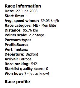
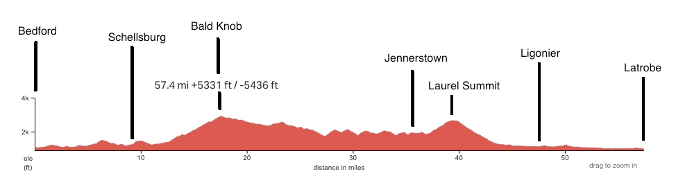
Friday’s race was from Bedford to Latrobe on U.S. Rte 30. This is a road I have traversed many times. While “only” 60 miles (95.76 km), this was predicted to be the stage to break open the race because of its two large mountain climbs. The first was out of Shellsburg up Bald Knob to the top of “Seven Mile Stretch.” As a kid, I remembered this route for the “Ship Hotel” which was a hotel built on the side of the mountain. It is only a memory now because after it closed and before it could be preserved, it burned to the ground in 2001. Arsonists surely.
I volunteered to be a course marshal in Bedford. I left the house at 5:30 a.m. for the three-hour drive to Bedford. Check-in time for volunteers was 9:00 a.m.
We had our orientation and I tried to decipher what the tour would really be about. I had followed the results on the Internet but the television coverage on Versus was a day behind and spotty at best. I had only seen the time trials.
I was especially curious if the cyclists had the entire road to themselves or just one lane westward. Answer: the entire road.
Our volunteer coordinator was Dave “Lumpy” Williams. He explained how good the Pennsylvania State Police were at sealing the highway to oncoming traffic. The front part of the caravan was all policemen and they forced any oncoming traffic to pull over and wait until the race passed. Our job was to be at intersections and make sure that vehicles did not enter the race course once the race was underway.
Lumpy was a very likable guy. When he talked about the race and used its proper name, he always ended with “presented by Highmark Health High-5” then did an “air” High-5. It never got old.
I volunteered to be as far out of town as I could get. Nothing against Bedford but some of the locals wanted to stay in town and I had my bike with me and wanted to ride. The positions were mostly for Bedford so Lumpy gave me the most distant one he had. I rode out to the intersection of Old U.S. 30 with U.S. 30.
Our job was also to be part ambassador. This was a role I was well suited for. Rather than tell a local they couldn’t use “their” road until the race passed, we could talk up the race and explain what it was all about. I met two families who had come out to the end of the street and I chatted with them the entire time.
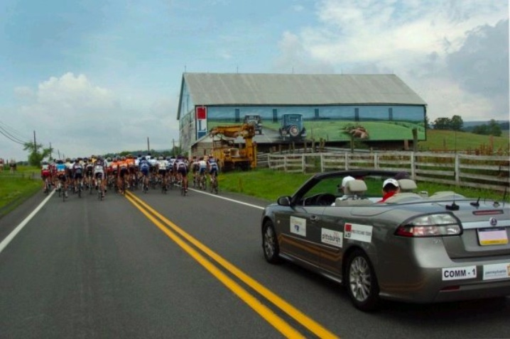
On U.S. 30, two miles west of Schellsburg at the “Buffalo Farm”
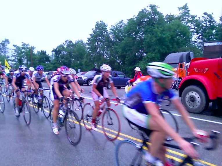
As soon as the race passed my course marshal location, I rode back into town where I had parked then got on the Pennsylvania Turnpike and went to Somerset. I then tried to get to Jennerstown as quickly as possible and almost lost. I was relieved that when I got to Jennerstown the caravan wasn’t there yet but make no mistake about it, these boys fly. Even climbing Bald Knob then Laurel Mountain, and some major hills in between, they would average more than 24 mph on this stage.
At the start of the day I had hoped that I would be assigned near the top of a mountain where one can see the cyclists going a bit slower. But the traveling road marshals were to be dropped off at the more remote locations including Laurel Summit, so I thought.
It was bright and sunny in Bedford when I left. Not so at the summit. It was chilly with light rain but mostly just chilly. The riders probably loved it while climbing, not so descending and I don’t think anyone had newspapers to hand to the riders to stuff in their jerseys for the cold descent to Ligonier.
When I arrived at the Laurel Hill summit parking was hard to find. There weren’t a lot of fans on the mountain, maybe 50-75, but enough had come out to cheer on the riders. There were even some cyclists who rode there, from Ligonier perhaps.
I found a couple of officials manning the KOM (King of the Mountains) point. I introduced myself as a volunteer. I was wearing my official American Outfitters Tour of Pa. staff shirt. The official told me I wasn’t needed there to help so I could go ahead and simple spectate.
And I did. The first riders, a group of 13 came over the summit to the delight of the crowd. But then three cars slipped into the race from the ski resort. The State Police quickly moved to remove them from the course and I quickly moved to seal off Laurel Summit Road from any other cars. I think it was supposed to be manned by a traveling marshal who just didn’t make it up the mountain in time. No other cars got on to the course.
Cresting Laurel Hill (Mountain)
The peloton was about 18 minutes down. That was a sizable gap. Once they cleared the crowd dispersed. And I followed. I had hoped they would have two-laned the eastbound lanes of Rte 30 between Ligonier and Latrobe and I would have a chance to pass the peloton before they reached the finish. No chance. As it was, I drove down the mountain but still didn’t catch the rear of the race until Kingston Dam at Latrobe. In fact, I never saw the race convoy, just lots of cars traveling 25 mph. Done for the day, I went back to Ligonier to go riding.
Stage 4: Bedford to Latrobe (Friday, June 27, 2008) (Start time: 10 a.m.) This 60-mile stage will push the riders to their limits with the most elevation gain and the hardest of all climbs in the event. After departing the town of Bedford, the roll will be easy for only 15 miles before turning upward for a difficult climb to Bald Knob Summit, the first KOM for the day. Bald Knob Summit is a 5.5-mile climb with grades of 10% to15 % and will surely decide the day’s top climbers, as they make their way up and over the Allegheny Mountains. After a slight rolling descent, the riders will again go uphill and crest the Laurel Hill Summit at mile 40 for the second KOM of the day. This 2-mile climb is shorter but with a very intense mountain pass that will also see grades of 15%. The descent into the last leg of the day will be fast, but will also have a flat section, rolling through Ligonier and following the river into Latrobe with a tricky sprint finish in the downtown area. This day is likely to be the hardest stage and will certainly separate the field, revealing who the potential leaders will be for the week.
I parked in Ligonier and first rode out U.S. 30 east towards Laughlintown, passing Ligonier Beach, the massive swimming pool next to the Loyalhanna Creek. It’s as pretty as it was when we lived there 40 years ago and even then it was 40 years old.
I came to State Route 381 and turned down the tree-lined road to Rector. It is bordered on both sides by post and rail fence, most of it belonging to Rolling Rock Farms and perhaps still, the Mellon Family. When we lived in Rector in the late 1960s, Richard King Mellon also lived here. It is here where they have the Rolling Rock Hunt.
Once in Rector, I rode up Old Linn Run Road as far as Devil’s Hole. Devil’s Hole is hard to find if you don’t know where to look. For years it had been a public swimming hole and sometimes people would drive from miles around to swim there. It was fed by a mountain stream and the water was always cold. In the late 60s and early 70s we helped to dam it every spring.
A large rock across the steam was the one that we would dive from. The water naturally in the pool area was about 3-4 feet deep. But each spring the locals would lift rocks and build a dam just downstream, often reinforcing it with plastic. Once it was dammed another 3 feet or so high the water in the middle was easily 6 feet deep. We sometimes would swim for hours and always our lips would be blue and our teeth would be chattering.
But a number of years ago the property owners, probably wisely, posted it with No Trespassing signs. In this day and age of lawsuits, who could blame them? The approach has been built up with a mound of dirt and had been grown in.
Linn Run Road used to connect all the way to Valley School of Ligonier but that too (the road, not the school) has been closed and probably has reverted to forest.
I turned and went back to the only intersection in Rector. I then passed the United Methodist Church and parsonage which is where we lived until 1971. I took Weaver Mill Road in front of the house to the top of the hill. It is short but steep. I remember getting my first 5-speed, one of those banana seat bikes with high handlebars. I was so proud the first time I was able to bike all the way up to the top of this hill. It was a little easier with the Trek Pilot 40 years later. Or I’m a little stronger.
I turned on Byers Lane and went over to Linn Run Road. I took Linn Run Road up to Linn Run State Park, but only as far as the Adams Falls area. Two things struck me about my ride up to the park. First how good of shape Linn Run Road was in. I never remember pavement this good on this road. And it wasn’t just my carbon fiber bike that does deliver a nice ride. The second was how bad the road was. Once I reached the state park the road deteriorated quickly. Had the road been in good shape I would have ridden much deeper into the park. But instead, I turned around for the nice descent back to Rector.
Once back to Rector Green I took Darlington Road which would take me up to Rte 711. This is an extremely steep hill which we would avoid in the winter when there was snow on the road. I wondered how steep it was and whether I could make it. Answer: Steep and yes. * But I pedaled on up the mile hill without difficulty. I turned on 711 and took the road back to Ligonier. Before I reached the town, I turned on Peters Road which cuts over to Rte 30. It also cuts through Laurel Valley Golf Club one of the premier private golf courses in the world.
When I returned to Ligonier I hadn’t yet pedaled for 20 miles so I went down around the high school, the school I attended in 10th grade in 1970-1971. I cut through the parking lot and ended up on Carey School Road. It is a short climb, maybe 1/4 mile, but pretty steep. On my descent, I went 45 mph.
As far as the race:
Canadian David Veilleux (Kelly Benefit Strategies-Medifast) proved to be the fastest on Stage 4, taking a convincing victory ahead of new race leader Christoff Van Heerden (Konica Minolta) and Dutchman Dennis Luyt (Global Cycling). The peloton endured a soaking wet stage, with the sun only coming out at the finish line in Latrobe, where spectators gathered to watch the tricky sprint finale in the downtown area.
“There is less than a second between us and so I think tomorrow is going to decide everything,” said the French-Canadian stage winner Veilleux. “It was really hard today, constantly up and down even between the two KOM’s. The goal today was to stay with the climbers.
“My team has been riding great this week and I am looking forward to the next couple of stages,” he added.
The relatively short stage was also considered the toughest of the race. The fourth stage, under 100 kilometres in length, was intended to further open the time gaps between the top GC riders. While the terrain did separate the field, the top overall contenders are still only separated by one second each.
In the end Stage 4 left Van Heerden as the new overall race leader. The South African leads the race overall just one second ahead of Veilleux and American Stefano Barberi (Z Team).
Notes: The course was U.S. Rte 30 from Bedford to Latrobe Won how: 12-man bunch sprintProfile created by Barry Sherry (unofficial)Credit: ProCyclingStats.comCredit: VeloNews: 18 Oct 2012
EPILOGUE: David “Lumpy” Williams died of a heart attack Tuesday, October 16, 2012, in San Rafael, California, at age 61.
It was 108° in Las Vegas on Sunday. On Monday and Tuesday, it was 105°. Still, I wanted to ride.
One year ago, almost to the day, I was in Las Vegas and drove out to Blue Diamond. From there I rode to Red Rock Canyon Scenic Drive. The run-in to the scenic drive has a safe shoulder and is a nice ride. On the scenic drive I rode with a young man from Seattle, named Tom. He told me that he had come in from Vegas. So this year I decided to ride the route Tom had ridden.
I rented a bike from the Las Vegas Cyclery on West Charleston Blvd. I picked it up the afternoon before and went back to my hotel, which was out by the airport. I then rode from the hotel to the strip in Vegas. It was hot, 105°, and I seemingly produced no sweat. I know the sweat was evaporating as soon as it came to the surface of my skin. It didn’t last long enough to cool me but I could see white salt deposits on my jersey.
When I got back to the hotel I wasn’t done riding for the day so I decided to do 10 laps of the parking lot. This was quite interesting. I would fly around two of the turns but on the third one hit a wall of wind. It was fun and dangerous. After a shower, I went to the lobby for the manager’s reception, also known as dinner. Here I looked up and saw Dan Foster and Mark Moreland, two colleagues from our Denver office. It’s always nice to run into people you know.
Early in the morning, the talk of the weather was of the cold front coming through. With it came high winds. I heard on one report that Red Rock Canyon was closed due to high winds, sustained at 50 mph or more. But I never heard that again.
I drove back out to the cyclery and knew I could follow the boulevard directly to the scenic drive. I didn’t know it would be all uphill. West Charleston Boulevard is a busy street, no shoulders, six lanes, with many traffic lights. But that lasts 3-4 miles before it turns into a desert highway. The climb up was windy. Very windy.
This cyclist would rather battle a head wind than a cross wind. And I had cross winds on the way out to the canyon. I kept a steady pace and kept the bike steady, which at times was hard to do.
I arrived at the Canyon and turned on the scenic drive. It is still free to cyclists; other users must pay. Here I started the climb and discovered I was climbing into a headwind. Maybe it was wind, maybe equipment, or maybe fitness, but it seemed a little harder than last year. But I reached the summit and took a couple of bad photos. It was very windy here.
I began the descent and wanted to let it out. It was fun descending quickly but also scary because of the winds. I reached the main road and headed back to Vegas. This portion was more open and more prone to high gusts of crosswinds. I struggled at times to keep the bike upright, all while maintaining a pretty high speed.
But it was all downhill and went pretty quickly. It was a nice ride — highly recommended for first-times to Vegas, but next time I have to find Mount Charleston Mountain and head out there.
I was not riding with GPS in Las Vegas so this route is the one that I followed.