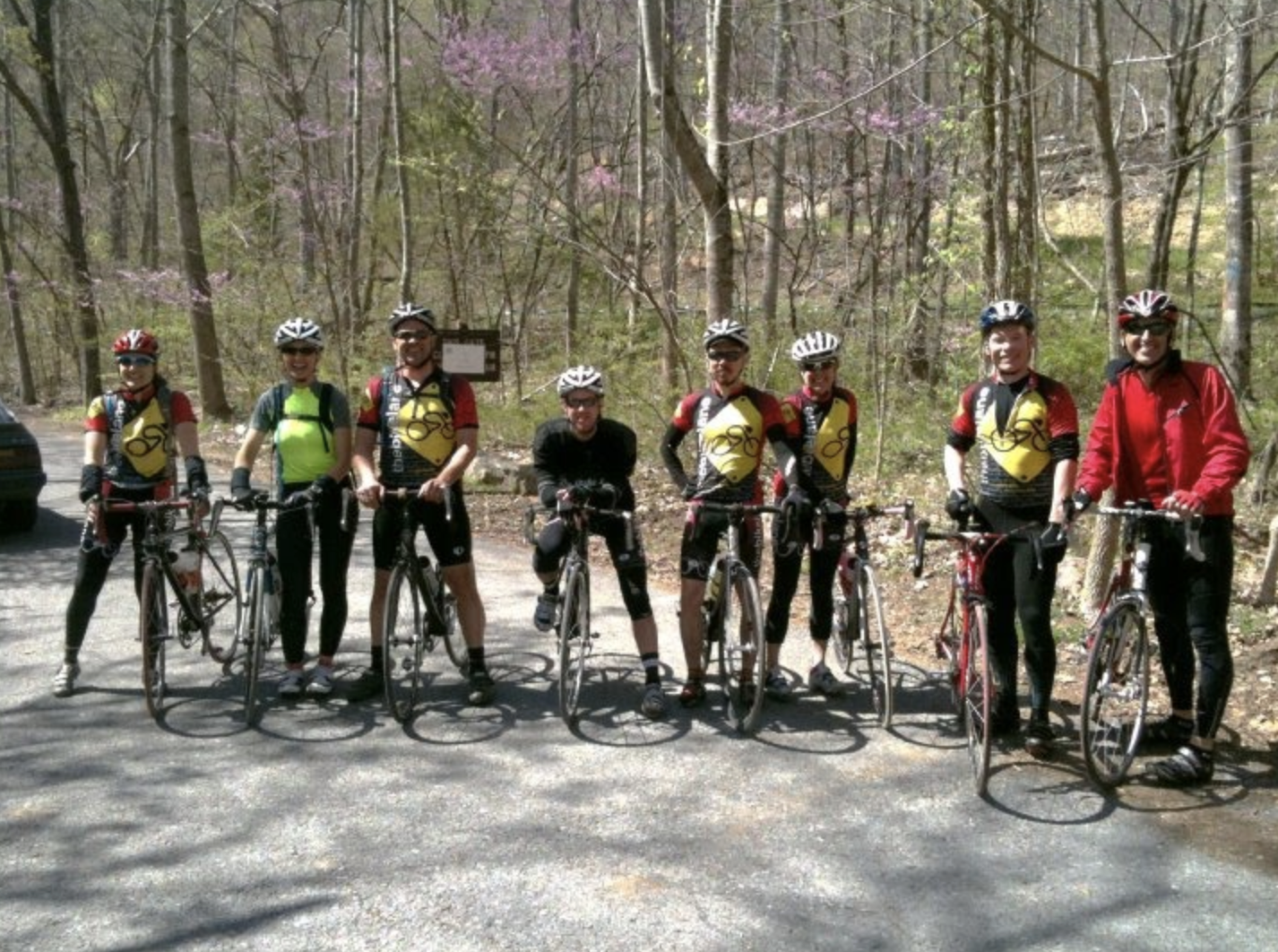
Sperryville and Skyline Drive

SPERRYVILLE, VIRGINIA

In preparation for Mt. Washington, I will not find an 8 mile 12% grade climb with 40 mph winds and near-zero visibility. So one must train under lesser conditions.

My Independence Day route took me to Sperryville, in Rappahannock Co., Virginia. Just as I arrived it started raining. I didn’t want to ride up the mountain in the rain and hoped to wait it out. I listened to WTOP news and their weather forecast described a storm over Rappahannock Co. which would be breaking up soon. As soon as the rain stopped I started up the mountain.

From Sperryville, it would be a seven-mile climb to the summit although the first two miles would be only a two percent grade or so. I started up the mountain. After the first two miles, it started raining. I didn’t avoid it after all but at least it was a light rain.

Until the road reaches Shenandoah National Park it is a two-lane road with no shoulder. I noticed the cars with cargo on their roof racks tended to give me a wide berth while vehicles without cargo often didn’t move out of the lane even when no opposing traffic was coming. I figured the tourists were more understanding than locals of cyclists on this road. Maybe I was wrong but it is what I thought.

Once in the park, the road widens to three lanes — two in the up direction so faster drivers can pass those in the slow lane.

There was one courteous driver who passed. He was the driver of an 18-wheeler and my only thought was why an 18-wheeler was even on this road. But I was on the “shoulder” at that point which was about six inches to the right of the road. I heard him behind me and noticed he wasn’t going to pass even though he could. He waited until there was no opposing traffic. I gave him a high wave when I heard his engine rev to thank him for waiting until there was more room to pass. He responded with a quick but light reply on his air horn.

I was tapping out a good rhythm and saw a sign that Skyline Drive was two miles away. Then I heard a loud clap of thunder. I hoped not to see lightning. My glasses were keeping the rain out of my eyes but were fogging up a bit. I thought I saw a flash but wasn’t sure. But then, I was sure.

There was thunder and lightning all around. I know the safest place on a bike during an electrical storm is not on a bike. If there was an opening one could lay down the bike and sit low away from any trees. But I was in a forest. My choices were to keep going or to turn around. I had come too far to turn around and I thought I might get through the storm quicker by going through it. I continued climbing.

The rain was coming down very hard. The gullies next to the road were running full and flowing across the road. At times I was battling not only gravity but currents too. I continued.

The heaviest part of the storm did not last long, no more than 10 minutes. I was soaked. I wondered what the few riders who passed me thought. I alternated my pedaling in and out of the saddle.

On my rear 10-speed cassette, I knew I wasn’t in my low gear. And that became intentional. I reasoned that if I am going to climb Mt. Washington I have to make lesser climbs a bit harder. Not using all my gears was part of my plan.

Unlike mountain or hybrid bikes, there is no click shifting with gear numbers on my road bike. It’s all done by feel and if one must know, a quick glance back to see where the chain is on the gears.

I approached the summit and the pedaling became easier. I had made it. I biked over the summit to Page Co., and then stopped to check out my gearing. I wasn’t even in my second gear. Or third. I had climbed to the summit of Skyline Drive in my fourth sprocket which gave me a great feeling about my fitness level for next weekend.

I turned around for the reward — a fast descent back down to Sperryville on wet roads.

Horseshoe Curve – The First Time

ALTOONA, PENNSYLVANIA

I was up early at my parent’s house in Friedens and decided to ride some more in the mountains. I drove to Jennerstown and parked on Main Street. I rode the mile or so out of town then the steep descent on U.S. Rte 30. After a quarter-mile drop, one is at the lowest point before the climb.

The Tour of Pennsylvania described this as a two-mile climb with a very intense mountain pass that sees grades of 15%. I had no problem going right up the mountain although not as fast as the boys did on Friday. I wanted to go over the top back to Laughingtown then come back up and over but the sky looked ominous. It looked like a storm was about to move into these mountains and I didn’t want to get caught in it. I turned around at the truck area and headed back to Jennerstown. I was disappointed that I never got above 45 mph on this descent.

I thought about driving over to Rector and going up, then down, Darlington Road again but wasn’t sure where the storm was and wanted to try something new. I drove to Altoona.

I had remembered an article Bicycling about the toughest 100 climbs in the U.S. One of those was the Horseshoe Curve climb in Altoona. I parked on 58th Street and started out towards Kittanning Point Road. The climb was up, past three reservoirs, but never very tough. As I climbed I heard a train creaking and breaking as it descended the Allegheny Mountains towards Altoona. It was way too easy that I reached Horseshoe Curve.
I couldn’t believe this was a tough climb. It wasn’t.

I saw a tunnel and went through it under the Horseshoe Curve. On the other side was a beautiful forested country road. I kept riding and it kept going up. And that was the new deal I made with myself. As long as the road turned up, I would keep riding.

My first trip up Horseshoe Curve
Tunnel at Horseshoe Curve

I saw a sign for Adopt a Highway and saw it was sponsored by Blair Co. Bicycle Club for the next four miles. I figured I had four miles. Cool.

After about three more miles I was getting tired. I was in my granny gear and was standing and sweating. But I kept moving without “paperboying” back and forth across the road to make the grade a little easier. Finally, it became easier.

I read later that this section is 10-12% but then one hits the wall at a 19% grade for a half mile before settling back to 12% for the last mile. That was it. And I made it. I love riding in these mountains.

I turned around. On the descent, I wanted to let it out. But this road had many curves and it was raining. The rain was following me. The last speed I saw was 43 mph in a curve. Then my computer went out. On the transmitter, a support broke off so it wasn’t in the right position to read the magnet on the spoke. I was doing 0 then 10 then 6 then 4 then 38.

I will need to come back and explore this more. Much more. It was everything as advertised especially “three lakes and a 200′ tunnel.” It is absolutely beautiful.

Tour of Pennsylvania – II

LIGONIER, PENNSYLVANIA

Stage 5: Ligonier to Pittsburgh (Saturday, June 28, 2008)
(Start time: 12 noon) This 83-mile stage will give the riders a more subdued ride as they enter into downtown Pittsburgh. The route will follow a mostly rolling course with one short KOM at mile 21 and one last intermediate sprint at mile 38 on the outskirts of Latrobe. The race will continue towards Pittsburgh with a sprint finish at the headquarters of title sponsor American Eagle Outfitters. Spectators should be prepared for a thrilling, four-corner downtown sprint finish.

I rode early in the morning and then went to the Diamond at 10:00 a.m. Dave “Lumpy” Williams thanked the volunteers and “without insulting the volunteers who came from other towns” opined that Ligonier was the prettiest town on the tour. I would agree. When Lumpy welcomed us he deadpanned the title, “The American Eagle Outfitters’ Tour of Pennsylvania presented by Highmark Healthy High 5,” stopping to raise his hand in the air to simulate giving a “High 5.”

Whereas in Bedford the volunteers were assigned to a location in town, this race was to start by the Fort just below the Diamond then head out of town on Rte 711. All our assignments were out 711 all the way to Donegal. I knew the location I wanted was the intersection with Darlington Road but when it was offered as the “unmarked four-way intersection” everyone just looked at each other then one person said he would find it. Only later did I realize which intersection it was – the one I wanted.

Still, it all worked out. I got to bike out past Stahlstown to Fort Hill Road, 10 miles exactly, mostly uphill. As I rode some locals thought I was leading the race and were cheering for me. But when asked I always stopped and told them what real racers looked like. “Young,” I told them.

I reached Fort Hill Road and rested my bike against a sign. There was a young mother, no older than 30, on an ATV with two small kids in a field across the road. I went to talk with them and told them how exciting it was to watch a race, especially with all the police cars and motorcycles. I was able to explain to them what they would see. Basically, a parade of cars, led out by state policemen, would be coming up the road. Media. Race referee. Then riders followed by team cars, doctor or ambulance, and the dreaded broom wagon.

Since we were at the bottom of a hill, the racers flew by in a matter of 3-4 seconds. And that was it. Pretty exciting, no?

I said goodbye, the family thanked me for explaining to them what the bike race was, and I headed back to Ligonier. As I left I saw the road was blocked and an ambulance was tending to someone in the ditch. The “broom wagon” had gone by with the caravan but had doubled back so we know some rider was done for the tour.

(Two riders, Alex Welch and Nathaniel English, were listed as Did Not Finish on this stage. Likely it was one of them.)


This morning I arrived in Ligonier and parked in front of my brother’s house although he was out of town. I rode back down to Carey School Road and climbed it again. It is steep and was a good climb for me. Again, like yesterday, my descent was 45 mph. I did a loop around the west end of town and then cut through the school parking lot again back to Carey School Road. This time when I reached the top I pedaled full out. I reached 46.5 mph which was a personal best on my bike.

I went to the Diamond at 10:00 a.m. to meet up with all the volunteers. Assignments were handed out and at first, I was disappointed it was so far out (10 miles) but I knew it gave me a chance to bike and not drive. It was mostly uphill out to Stahlstown which gave me a chance to pass my fellow volunteers who had been stationed at every intersection along Rte 711 and had driven to their assignments.

My return to Ligonier could have been a 10-mile run-in on Rte 711 but when I came to Darlington Road to Rector I decided to go down the road I went up the day before. The road is scary steep.

It was 1970 or 1971 that my brother, Brad, was on this hill on his bike. I can’t imagine that he was far up the road because no one would venture that high. But he was on a bike, just 10 or 11 years old, and on his descent, he hit some gravel at the bottom of the hill where the bridge crosses Loyalhanna Creek and crashed hard. He chipped a front tooth and was generally messed up.

This was in the back of my mind as to whether I even wanted to go down this road, let alone fly down this road. I approached the top of the hill, which is flat, with trepidation. I looked behind me and a car was coming up on me. My thought turned to the car as to whether or not he would try to pass on this narrow country road that went straight down. That would be no problem.

I pedaled, though not hard at first. My speed went from 20 to 25 and then to 30. I looked back and the car was farther back. My speed was 35 then 40. I was headed down and was pedaling even harder. The speed was 45 then 46.5. I last saw it at 49 but couldn’t risk looking at the speedometer. I had to watch the road and worry about the bridge where Brad wiped out.

I finally just got in a tuck and let it roll. This was a combination of adrenaline rush and excitement mixed with pure terror. In other words, it was great! I flew across the bridge and as I was rolling on a slight uphill, looked down to view my high speed. It was 49.8. I guess I can round it to 50 mph! (I didn’t.) That was a personal best.

I then casually rode Rte 381 back to Rte 30 then took Old Rte 30 back into town. I wasn’t sure if or where to ride next.

I drove out Rte 30 headed back to my parents in Somerset and came to Laughlingtown. And I thought, “Why not?”

I parked and got my bike out and decided I would ride up Laurel Mountain from Laughlintown. The distance to the summit is 3.5 miles and the signs at the top warn of an 8% descent. I hadn’t biked far this day, only 20-25 miles, but wondered how my legs would be on a 4-mile climb. Basically, they did fine. I made it with no problems and no stopping.
I was disappointed in my descent. My speed was only 40-45 mph which was the posted speed limit. I bet the Tour riders on Friday were 10 mph faster.


As far as the race:

The American Eagle Outfitters Tour of Pennsylvania presented by Highmark Healthy High 5 neared its end as the international U25 field entered onto the Pittsburgh streets in the race’s penultimate stage five. The peloton began what was considered an early sprint in pursuit of a break of six riders that cleared the peloton mid-race. The finishing circuits showcased Pittsburgh’s newly built shopping district before an exciting finish outside of the American Eagle Outfitters world headquarters. The pair of French-Canadians, David Veilleux and Keven LaCombe (Kelley Benefit Strategies-Medifast), shocked the Pittsburgh crowds when they emerged out of the final bend with a sizeable lead over one remaining rider from the original breakaway, American Phil Gaimon (Fiordifrutta). “It feels great to have the leaders jersey and this was our plan since our meeting in the morning,” admitted stage winner, Overall Race leader and Best Sprinter leader, David Veilleux. “We planned to have Keven and I jump together and surprise everyone in the last part of the circuits.” Both Veilleux and LaCombe crossed the victory line together, applauding one another for their cagey tactics that moved Veilleux into the American Eagle Outfitters yellow leaders jersey, two seconds ahead of the previous leader from South Africa, Christoff Van Heerden (Konica Minolta) and American Stefano Barberi (Z-Team). The 91-mile stage gave the international U-25 field a more subdued ride as they entered into the City of Pittsburgh.


The route followed a mostly rolling course with one short VisitPA.com KOM around mile 22, made obsolete by the event’s leading climber from Boulder, Colo., Peter Stetina (VMG-Felt) who solidified his lead of the climber’s competition during the previous stage. The early miles also presented the sprinter with one last intermediate hot spot at mile 37, on the outskirts of Latrobe. American Chance Nobel (California Giant Berry Farms) scooped up the full points during his solo breakaway that gained nearly two minutes on the field. A second breakaway of three riders let loose on the second half of the stage to include Australian Forbes Trail Most Aggressive Rider Dylan Newell (Praties), the Belgian Steven Van Vooren (Johan Brunyeel Cycling Academy) and South African Travis Allen (Konica Minolta). The trio was later joined by three more Americans, Sheldon Deeny (Sakonnet Technology), Caleb Fairly (VMG) and third place in today’s stage, Phil Gaimon. “It was pretty tough out there with really strong headwinds,” said Newell. “I thought they would let us hang out there for a while, but I didn’t think it would stay away until the last lap of the finishing circuits.”

Source: ProCyclingStats.com

Knowing how steep Darlington Road is was important to me. So I wrote to a local bike shop, Speedgoat Bicycles in Laughlintown, Pa. I never shopped there and they certainly didn’t owe me a response but I got one — a great one. I will definitely stop there the next time I’m back in Ligonier Valley.

While we certainly have much steeper climbs in the neighborhood (I tend to rate them according to how close my tongue is to the road immediately in front of my face), Darlington up to 711 is only considered “steep.” This is worse than “not steep” but not nearly as bad as “pretty steep,” “real steep,” “damn steep,” and our peculiar regional Hors Category col nomenclature, “sucks.”

I’ve also towed my twins up that road with standard road gearing, and I can quickly think of five climbs also within ten miles of the shop that I’d definitely not try that on. So it’s probably not too bad, though I don’t have hard numeric data for you. We have good customers who’ve done the Mt. Washington race/ride multiple times, and it appears that the length is also a major factor. The very, very bottom section of Darlington road probably does spike over 15%, and then it wanders back and forth under that initial grade.

Apparently, Mt. Washington would be like going up that thing repeatedly for seven-and-a-half miles. With oxygen depletion, fog, and freezing temperatures waiting at the top. Depressing, but hopefully helpful, too. That Mt. Washington climb is “brutal.”

Using my Garmin Edge 705 GPS, I later measured Darlington Road at 10-11% grade. However, turn off and head up Country Club Road and that goes at 12%.

Tour of Pennsylvania

BEDFORD, PENNSYLVANIA

Officially, “The American Eagle Outfitters’ Tour of Pennsylvania presented by Highmark Healthy High 5.”

This was the first in hopefully what is the start of an annual event. The Tour of Pennsylvania. It joins the Tours of California, Georgia, and Missouri but was unique in that it was for Espoir riders, those elite international professionals ages 19-24. With $150,000 in prize money, it was believed to be the largest purse in the world for young riders. But it was a signature event for Pittsburgh 250, a commission to celebrate Pittsburgh’s 250th anniversary in 2008. Much of the sponsor money came from this budget and it also helped celebrate the 250th anniversaries of Bedford, Latrobe, and Ligonier thus they all played prominent roles in hosting the tour.

The race started on Tuesday in Philadelphia with a prologue time trial and criterium. On Wednesday it was a road race from Downingtown to Carlisle. On Thursday it was a stage race from Camp Hill to Bedford.

Friday’s race was from Bedford to Latrobe on U.S. Rte 30. This is a road I have traversed many times. While “only” 60 miles (95.76 km), this was predicted to be the stage to break open the race because of its two large mountain climbs. The first was out of Shellsburg up Bald Knob to the top of “Seven Mile Stretch.” As a kid, I remembered this route for the “Ship Hotel” which was a hotel built on the side of the mountain. It is only a memory now because after it closed and before it could be preserved, it burned to the ground in 2001. Arsonists surely.

I volunteered to be a course marshal in Bedford. I left the house at 5:30 a.m. for the three-hour drive to Bedford. Check-in time for volunteers was 9:00 a.m.

We had our orientation and I tried to decipher what the tour would really be about. I had followed the results on the Internet but the television coverage on Versus was a day behind and spotty at best. I had only seen the time trials.

I was especially curious if the cyclists had the entire road to themselves or just one lane westward. Answer: the entire road.

Our volunteer coordinator was Dave “Lumpy” Williams. He explained how good the Pennsylvania State Police were at sealing the highway to oncoming traffic. The front part of the caravan was all policemen and they forced any oncoming traffic to pull over and wait until the race passed. Our job was to be at intersections and make sure that vehicles did not enter the race course once the race was underway.

Lumpy was a very likable guy. When he talked about the race and used its proper name, he always ended with “presented by Highmark Health High-5” then did an “air” High-5. It never got old.

I volunteered to be as far out of town as I could get. Nothing against Bedford but some of the locals wanted to stay in town and I had my bike with me and wanted to ride. The positions were mostly for Bedford so Lumpy gave me the most distant one he had. I rode out to the intersection of Old U.S. 30 with U.S. 30.

Our job was also to be part ambassador. This was a role I was well suited for. Rather than tell a local they couldn’t use “their” road until the race passed, we could talk up the race and explain what it was all about. I met two families who had come out to the end of the street and I chatted with them the entire time.

On U.S. 30, two miles west of Schellsburg at the “Buffalo Farm”

As soon as the race passed my course marshal location, I rode back into town where I had parked then got on the Pennsylvania Turnpike and went to Somerset. I then tried to get to Jennerstown as quickly as possible and almost lost. I was relieved that when I got to Jennerstown the caravan wasn’t there yet but make no mistake about it, these boys fly. Even climbing Bald Knob then Laurel Mountain, and some major hills in between, they would average more than 24 mph on this stage.

At the start of the day I had hoped that I would be assigned near the top of a mountain where one can see the cyclists going a bit slower. But the traveling road marshals were to be dropped off at the more remote locations including Laurel Summit, so I thought.

It was bright and sunny in Bedford when I left. Not so at the summit. It was chilly with light rain but mostly just chilly. The riders probably loved it while climbing, not so descending and I don’t think anyone had newspapers to hand to the riders to stuff in their jerseys for the cold descent to Ligonier.

When I arrived at the Laurel Hill summit parking was hard to find. There weren’t a lot of fans on the mountain, maybe 50-75, but enough had come out to cheer on the riders. There were even some cyclists who rode there, from Ligonier perhaps.

I found a couple of officials manning the KOM (King of the Mountains) point. I introduced myself as a volunteer. I was wearing my official American Outfitters Tour of Pa. staff shirt. The official told me I wasn’t needed there to help so I could go ahead and simple spectate.

And I did. The first riders, a group of 13 came over the summit to the delight of the crowd. But then three cars slipped into the race from the ski resort. The State Police quickly moved to remove them from the course and I quickly moved to seal off Laurel Summit Road from any other cars. I think it was supposed to be manned by a traveling marshal who just didn’t make it up the mountain in time. No other cars got on to the course.

Cresting Laurel Hill (Mountain)

The peloton was about 18 minutes down. That was a sizable gap. Once they cleared the crowd dispersed. And I followed. I had hoped they would have two-laned the eastbound lanes of Rte 30 between Ligonier and Latrobe and I would have a chance to pass the peloton before they reached the finish. No chance. As it was, I drove down the mountain but still didn’t catch the rear of the race until Kingston Dam at Latrobe. In fact, I never saw the race convoy, just lots of cars traveling 25 mph. Done for the day, I went back to Ligonier to go riding.


Stage 4: Bedford to Latrobe (Friday, June 27, 2008)
(Start time: 10 a.m.) This 60-mile stage will push the riders to their limits with the most elevation gain and the hardest of all climbs in the event. After departing the town of Bedford, the roll will be easy for only 15 miles before turning upward for a difficult climb to Bald Knob Summit, the first KOM for the day. Bald Knob Summit is a 5.5-mile climb with grades of 10% to15 % and will surely decide the day’s top climbers, as they make their way up and over the Allegheny Mountains. After a slight rolling descent, the riders will again go uphill and crest the Laurel Hill Summit at mile 40 for the second KOM of the day. This 2-mile climb is shorter but with a very intense mountain pass that will also see grades of 15%. The descent into the last leg of the day will be fast, but will also have a flat section, rolling through Ligonier and following the river into Latrobe with a tricky sprint finish in the downtown area. This day is likely to be the hardest stage and will certainly separate the field, revealing who the potential leaders will be for the week.


I parked in Ligonier and first rode out U.S. 30 east towards Laughlintown, passing Ligonier Beach, the massive swimming pool next to the Loyalhanna Creek. It’s as pretty as it was when we lived there 40 years ago and even then it was 40 years old.

I came to State Route 381 and turned down the tree-lined road to Rector. It is bordered on both sides by post and rail fence, most of it belonging to Rolling Rock Farms and perhaps still, the Mellon Family. When we lived in Rector in the late 1960s, Richard King Mellon also lived here. It is here where they have the Rolling Rock Hunt.

Once in Rector, I rode up Old Linn Run Road as far as Devil’s Hole. Devil’s Hole is hard to find if you don’t know where to look. For years it had been a public swimming hole and sometimes people would drive from miles around to swim there. It was fed by a mountain stream and the water was always cold. In the late 60s and early 70s we helped to dam it every spring.

A large rock across the steam was the one that we would dive from. The water naturally in the pool area was about 3-4 feet deep. But each spring the locals would lift rocks and build a dam just downstream, often reinforcing it with plastic. Once it was dammed another 3 feet or so high the water in the middle was easily 6 feet deep. We sometimes would swim for hours and always our lips would be blue and our teeth would be chattering.

But a number of years ago the property owners, probably wisely, posted it with No Trespassing signs. In this day and age of lawsuits, who could blame them? The approach has been built up with a mound of dirt and had been grown in.

Linn Run Road used to connect all the way to Valley School of Ligonier but that too (the road, not the school) has been closed and probably has reverted to forest.

I turned and went back to the only intersection in Rector. I then passed the United Methodist Church and parsonage which is where we lived until 1971. I took Weaver Mill Road in front of the house to the top of the hill. It is short but steep. I remember getting my first 5-speed, one of those banana seat bikes with high handlebars. I was so proud the first time I was able to bike all the way up to the top of this hill. It was a little easier with the Trek Pilot 40 years later. Or I’m a little stronger.

I turned on Byers Lane and went over to Linn Run Road. I took Linn Run Road up to Linn Run State Park, but only as far as the Adams Falls area. Two things struck me about my ride up to the park. First how good of shape Linn Run Road was in. I never remember pavement this good on this road. And it wasn’t just my carbon fiber bike that does deliver a nice ride. The second was how bad the road was. Once I reached the state park the road deteriorated quickly. Had the road been in good shape I would have ridden much deeper into the park. But instead, I turned around for the nice descent back to Rector.

Once back to Rector Green I took Darlington Road which would take me up to Rte 711. This is an extremely steep hill which we would avoid in the winter when there was snow on the road. I wondered how steep it was and whether I could make it. Answer: Steep and yes. *
But I pedaled on up the mile hill without difficulty. I turned on 711 and took the road back to Ligonier. Before I reached the town, I turned on Peters Road which cuts over to Rte 30. It also cuts through Laurel Valley Golf Club one of the premier private golf courses in the world.

When I returned to Ligonier I hadn’t yet pedaled for 20 miles so I went down around the high school, the school I attended in 10th grade in 1970-1971. I cut through the parking lot and ended up on Carey School Road. It is a short climb, maybe 1/4 mile, but pretty steep. On my descent, I went 45 mph.


As far as the race:

Canadian David Veilleux (Kelly Benefit Strategies-Medifast) proved to be the fastest on Stage 4, taking a convincing victory ahead of new race leader Christoff Van Heerden (Konica Minolta) and Dutchman Dennis Luyt (Global Cycling). The peloton endured a soaking wet stage, with the sun only coming out at the finish line in Latrobe, where spectators gathered to watch the tricky sprint finale in the downtown area.

“There is less than a second between us and so I think tomorrow is going to decide everything,” said the French-Canadian stage winner Veilleux. “It was really hard today, constantly up and down even between the two KOM’s. The goal today was to stay with the climbers.

“My team has been riding great this week and I am looking forward to the next couple of stages,” he added.

The relatively short stage was also considered the toughest of the race. The fourth stage, under 100 kilometres in length, was intended to further open the time gaps between the top GC riders. While the terrain did separate the field, the top overall contenders are still only separated by one second each.

In the end Stage 4 left Van Heerden as the new overall race leader. The South African leads the race overall just one second ahead of Veilleux and American Stefano Barberi (Z Team).

Notes: The course was U.S. Rte 30 from Bedford to Latrobe
Won how: 12-man bunch sprint
Profile created by Barry Sherry (unofficial)
Credit: ProCyclingStats.com

Credit: VeloNews: 18 Oct 2012

EPILOGUE: David “Lumpy” Williams died of a heart attack Tuesday, October 16, 2012, in San Rafael, California, at age 61.

Red Rock Canyon

LAS VEGAS, NEVADA

It was 108° in Las Vegas on Sunday. On Monday and Tuesday, it was 105°. Still, I wanted to ride.

One year ago, almost to the day, I was in Las Vegas and drove out to Blue Diamond. From there I rode to Red Rock Canyon Scenic Drive. The run-in to the scenic drive has a safe shoulder and is a nice ride. On the scenic drive I rode with a young man from Seattle, named Tom. He told me that he had come in from Vegas. So this year I decided to ride the route Tom had ridden.

I rented a bike from the Las Vegas Cyclery on West Charleston Blvd. I picked it up the afternoon before and went back to my hotel, which was out by the airport. I then rode from the hotel to the strip in Vegas. It was hot, 105°, and I seemingly produced no sweat. I know the sweat was evaporating as soon as it came to the surface of my skin. It didn’t last long enough to cool me but I could see white salt deposits on my jersey.

When I got back to the hotel I wasn’t done riding for the day so I decided to do 10 laps of the parking lot. This was quite interesting. I would fly around two of the turns but on the third one hit a wall of wind. It was fun and dangerous. After a shower, I went to the lobby for the manager’s reception, also known as dinner. Here I looked up and saw Dan Foster and Mark Moreland, two colleagues from our Denver office. It’s always nice to run into people you know.

Early in the morning, the talk of the weather was of the cold front coming through. With it came high winds. I heard on one report that Red Rock Canyon was closed due to high winds, sustained at 50 mph or more. But I never heard that again.

I drove back out to the cyclery and knew I could follow the boulevard directly to the scenic drive. I didn’t know it would be all uphill. West Charleston Boulevard is a busy street, no shoulders, six lanes, with many traffic lights. But that lasts 3-4 miles before it turns into a desert highway. The climb up was windy. Very windy.

This cyclist would rather battle a head wind than a cross wind. And I had cross winds on the way out to the canyon. I kept a steady pace and kept the bike steady, which at times was hard to do.

I arrived at the Canyon and turned on the scenic drive. It is still free to cyclists; other users must pay. Here I started the climb and discovered I was climbing into a headwind. Maybe it was wind, maybe equipment, or maybe fitness, but it seemed a little harder than last year. But I reached the summit and took a couple of bad photos. It was very windy here.

I began the descent and wanted to let it out. It was fun descending quickly but also scary because of the winds. I reached the main road and headed back to Vegas. This portion was more open and more prone to high gusts of crosswinds. I struggled at times to keep the bike upright, all while maintaining a pretty high speed.

But it was all downhill and went pretty quickly. It was a nice ride — highly recommended for first-times to Vegas, but next time I have to find Mount Charleston Mountain and head out there.


I was not riding with GPS in Las Vegas so this route is the one that I followed.

a

Riverride

KILMARNOCK, VIRGINIA
I left the house at 4:30 a.m. to drive to Kilmarnock for the 2nd Annual River Ride. We met at a YMCA Camp and I was on the road at 7:45 a.m.
At 7:46 a.m. the phone rang. It was a referee wanting to know the rules for his U10 matches at 9:00 a.m. Now maybe that wouldn’t have been so bad but yesterday I included in my weekly message to referees not to contact me for answers you can find yourself. I explained to the referee the rules, briefly, and then instructed him to find and print the rules himself. Just one day to myself with referees or coaches calling. Is that too much to ask? Grrr.
This ride was much different from the Blue Ridge Extreme Challenge. That ride had a mass start at 7:30, this one did not. Actually, I learned later there was a mass start at 7:30 for those who wanted it. I just couldn’t get there in time. But it wasn’t required. Riders after 7:30 departed when they wanted so we all straggled out on our own. And I was there by 7:30 but certainly didn’t see much of a mass start.
One bank clock displayed the temperature in Kilmarnock as 48 degrees although it was in the mid-fifties when I was ready to go. I had on a jacket and a backpack (Camelbak) so I could remove the jacket later. Just before I started I noticed a young lady in a tank top. I thought if she could go sleeveless, I surely could get rid of the jacket. I took off the extra clothes and went out in just my bike jersey. It was chilly but not too uncomfortable and it would warm up into the high 70s during the ride.
I rode the first 10 miles solo then stopped at the first food stop at Shiloh. I needed to keep my energy level high although hated to use the time to stop. This ride was to be important to me. I am still experimenting with nutrition both before and during the ride and needed to monitor what I ate.
Funny thing about these rides. If you catch someone, you are, by definition, faster than them so you probably don’t want to ride with them. Likewise, if someone catches you, they are faster and you normally wouldn’t ride with them. But I had three high school kids go flying by me and in an instant I decided I would “catch their wheel.” I accelerated and fell in behind them and then there were four of us.
They weren’t too skilled in using pace lines as one guy seemed to do all the riding up front. Eventually I went forward to take a turn pulling. And one needed to. It was a gorgeous day but very windy. On the flat terrain it seemed we were always going into a head wind (someone explain that to me someday) and the leader up front works about 30% harder than the following riders.
We rode together for about three miles when three other guys went flying by. They were probably in the early 30s. I couldn’t believe it when the high schoolers jumped on their wheels. I almost got left behind by the quick acceleration but soon there were seven of us in a line just loving life as we past a scores of riders.
Image I wanted to capture but couldn’t: Seven riders in a straight line and I was on the rear. I could only see the guy in front of me but the low rising sun made for a beautiful silhouette of seven riders on bikes. What great shadows. I would have loved to have sat up and been able to snap a photo but obviously couldn’t.
We rode together for about 10 miles when one of the teens dropped off. As they were discussing whether or not to slow and wait for him, another dropped and then the third. And I thought they would drop this old guy! I was disappointed because I thought I might ride with these guys for most of 90 miles. I saw them briefly at the next rest stop (Heathsville, Mile 28) and then never again.
I rode solo most of the way to the next stop. I passed a few guys along the way and was in visual contact with a rider from Kenya. Not too far from the Morattico rest stop (Mile 50) I was passed by three guys in a line riding hard. I decided not to chase them and then a woman went flying by and said “those assholes are going so fast.” I said “you can ride on their wheel if you want, I’m not.” I think she was with them and was upset they were dropping her. But within a half mile or so I was riding on her wheel and we went into Morattico together.

Morattico

 Morattico was very pretty. It’s hard to believe that the Rappahannock River here, which it borders on, is the same river that flows through Fredericksburg. Here is it quite wide just a few miles before it runs into the Chesapeake Bay. The rest stop was at a town museum. I visited the very small, and quaint, post office. The postmaster saw me and said “we don’t even have a bathroom here. We have to go next door.” I guess she saw a stranger in bike clothes and assumed I wanted to use the restroom. I didn’t. Since I work at USPS headquarters in Washington, D.C., I enjoy meeting some of our workers.
The run in to Morattico was a stem, one of two on the day, and I only saw about six riders on their way back out. But when I left I saw a number of riders going to the rest stop. I must have been ahead of most riders.
The routes weren’t well-marked. I say that because if I have doubt that I’m on the right road then they’re not well-marked. At some intersections there were small arrows pointing direction. The ride consisted of four loops, and depending on which ride you had to choose the right arrows. If you didn’t carry a course map, and I didn’t, you had to remember that we started with pink then went to green, then red, then orange, then red, then green, then pink. Easy.
In other words, if you came to an intersection that had both green and red arrows, you had to remember which one to take. They weren’t marked “Century – right” and “Metric – left.” Sounds confusing although now once I’m home thinking about it a simple way for century riders was every time we came to two colors, take the new one. Of course, that worked only if you could remember which one you were on. Sounds simple now but it wasn’t so much out on the road by yourself.
I was on my own after Morattico and turned down a two-lane highway. The pavement was great but I couldn’t see anyone in the distance or behind me. I started doubting that I was on the right road and pondered just packing it in for the day. After 10 miles on my own I came to an arrow and saw a sign for a ferry. I had remembered this as a feature and gladly rode to the ferry. When I arrived they were loading. It held seven bikes and two cars. There was a water stop there and I was told they were finally glad to see some riders. I was only the 12th rider to come by out of 150 or so registered century riders. Everyone really was behind me.
The road leading in was Ottoman Ferry Road and the ferry crosses the Western Branch of the Corrotoman River. It has to be one of the shortest rivers in the world but it is pretty wide where we crossed. It was a treat to take the ferry to the other side. This marked 63 miles covered.

Ottoman Ferry

Two riders went ahead, one visited the porta-john, leaving four of us together. We began a climb, described as a three-mile climb but after Blue Ridge Challenge, I can’t remember anything other than a slight uphill. A husband and his wife were in front (in the picture above on the ferry), followed by Thomas, then me.
I first started talking to Thomas on the ferry. He had been behind me and I was surprised he made it to the ferry when I did. I found out that he lives in the Virginia Beach area but was originally from Kenya. Thomas was good at sitting on people’s wheel and he gladly rode the third position in our line of four.
It was windy and it’s always hard to set the pace for the freeloaders behind. After a while I rode to the front and told the husband that I would set pace for them since he had been doing all the work. I fought the wind and kept going. After half a mile I came to a new color and we turned. I was surprised to see that I inadvertently dropped the husband and wife and was pulling just Thomas. And we would ride together the rest of the way.
Mostly I pulled but Thomas took some turns up front as well. We were a team. We stopped at Irvington (Mile 80) not realizing this rest stop was only two miles from the lunch stop at White Stone. We didn’t spend long at lunch, the live bluegrass band helped encourage us to leave sooner, and we headed for the last 24 miles.
A large portion of this was out on the peninsula to Windmill Point where the Rappahannock empties into the Chesapeake. It was very windy out here. On our way out we had passed a family coming back and we did overtake them after we turned around. This really was a highlight. The father piloted a 3-seat Co-Motion tandem with his two young daughters aboard. They looked to be about 5 and 3 years old. The younger one was slumped over sleeping, her head across her folded arms. But her feet were clipped in and her legs were still peddling. Priceless. The mother rode behind and she pulled a Burley trailer with a one year old inside. Sleeping.
At 100 miles, my century, I came in at 5:58 riding time and an hour more total stop time for rest breaks and the ferry crossing. My average speed was 16.7 which is what one needs to ride a 6-hour century. The total distance on the day was 104 and I could celebrate with ice cream at the finish. And a shower at the campground.
I waited for the family of five to arrive to talk with them although I didn’t ask any questions. I should have.
It was a nice ride although I enjoyed the support and terrain of the Blue Ridge Challenge more. This was too flat for my taste although the wind made it a challenge especially when I wasn’t in a line which was most of the day. I think I would rather climb for much of the day than ride on flats in such wind. I don’t know if I would do this one again but it sure was a beautiful route.

NOT MY Cousin Floyd

WOODBRIDGE, VIRGINIA

This does not make sense. The arbitration decision in the Floyd Landis case was just released with a 2-1 decision against Floyd. The panel ruled that the French lab did not follow World Antidoping Guidelines in testing Floyd’s samples. They further ruled that “if the practice is continued that future results would be overturned.”

Huh? So future results by the same lab using the same flawed procedures would be overturned but these ones would be accepted?

To the uninitiated, after bonking on Stage 16 in the Tour de Farce, Floyd rode away to a victory the next day. While he was hailed as having ridden one of the great races ever, the truth was he rode well — but not like Superman. The teams that should have organized early and chased failed to do so which allowed him to open a nine-minute lead on them.

Floyd knew if he won the stage he would be tested. It would be foolish to cheat. Floyd stood up like a man and at every opportunity maintained his innocence, all the way to the Court for Arbitration for Sport. They were especially annoyed that he had the balls to fight the charges and not only found against him on June 30, 2008, but also fined him $100,000. How dare someone questions their authority.

I met Floyd in January 2007. He came away as believable to me. For full disclosure, I have to mention that I am a genealogist. I trace some of my ancestry to a Landis family in Lancaster Co., Pa. in the 1700s. Floyd, of course, is from a Mennonite family named Landis in Lancaster Co., Pa. However, I have traced some of Floyd’s lineage and have yet to make a connection. Cousin or not, I believe him.

A real analysis of the data is at Trust But Verify. Another good blog is Free Floyd Landis.


AUGUST 17, 2010 — Well, aren’t we all the fools? In May at the Amgen Tour of California, Floyd, after being denied entry into the Tour, followed through with his blackmail threat and claimed that he and Lance Armstrong were dopers.

In January 2007, Floyd made his rounds proclaiming his innocence and asking for money from people like me. And I gave. Twenty-five dollars to attend his stupid Evening with Floyd event. Then $50 and $25. And I bought his book. And it was all a lie.

Floyd – I want my money back.

Floyd and Barry, Arlington Draft House, Arlington, Va., January 2007

FEBRUARY 29, 2012 — It continues. And it’s going to continue.

I don’t want my money back. Floyd lost his best friend, his wife (who may have been his best friend), his family, his house, his money, his integrity. He can keep my money.

I have my own theory. I believe Floyd was innocent of using artificial testosterone as he was charged. I suspect when he heard he was caught he thought “oh crap” but when he realized it was artificial testosterone, he fought that. In the end, they wore him down and he eventually confessed to being a doper – at least using blood transfusions.

Unlike Lance, he was not a good liar. It was his good Mennonite upbringing. In his first press conference after the initial doping allegations, Landis was asked flat out: “Have you ever taken performance-enhancing drugs before?”

After a pause, he replied: “I’ll say no.”

I think he speaks the truth about doping in the peloton but he lost his credibility by not confessing when he had a chance and down is discredited at every chance.

And we have found no genealogical link between us. Floyd is not my cousin.


EDIT/EPILOGUE – Ten years after the race, I had the chance to talk to one of the inner members on Floyd’s team, Team Phonak. Floyd bonked on Stage 16. But then, apparently having lost the Tour, he drank a bottle of Jack Daniels (which would be part of his convoluted defense). His team was pissed at him for drinking that night.

The team member put together two lists. And at three in the morning, woke Floyd up screaming at him. He said he had two lists: Why Floyd is the biggest A-hole in the world and Ways Floyd could regain the time he lost and still won the Tour. Which did he want?

Floyd chose how to win the Tour. Team Phonak had a plan. First, Floyd would have to get into the breakaway that sticks. And, no longer within striking distance of winning, the teams should let him go. Second, once in the break, he would have to attack them and go solo. And here was the real plan. Since it was a very hot day, almost 100°, being in a solo breakaway would give Floyd access to his team car. Indeed, throughout the stage one can see Floyd next to the team car, taking on water, often pouring it over his head to keep his core temperature down.

They had prepared 200 bottle of ice water that day. At least 100 would be dumped over his head. Not only would Floyd have access to cold water while riding this day, each bottle would be a “sticky bottle.” At 200 bottle hand-offs, and three seconds per bottle, this was the equivalent of holding onto the team car for 10 minutes. This would be a huge savings of energy. It was also pushing the rules if not breaking them, but much like soccer, you play to the level the referees permit.

Once Floyd got the lead, he held it. My recollection was he did not gain more time on the climbs against the peloton but did gain time on the descents. So when he won that day, his team merely thought their plan worked to perfection.

If Floyd doped, he apparently did it without knowledge of his team. After he had left Postal (USPS Cycling) whatever doping he did was on his own. He tried dirty doctors but found he couldn’t trust them. I don’t recall if he testified that he doped that night with his Jack Daniels or if he was popped for elevated levels of synthetic testosterone because he had doped in preparation for the Tour. Whatever it was, he was popped and the team would lose its title sponsor. Twenty-eight cyclists and support staff were now out of work because of Floyd.

Not my Cousin Floyd.

Getting Buzzed and It’s Not a Good Thing

MONTCLAIR, VIRGINIA

I did a stupid thing this afternoon. Much of my riding around Prince William County is on the bike paths/trails which follow the new roads in the county, particularly on Rte 234. But I need to take local roads to get there and Waterway Drive through Montclair is one of them.

Waterway Drive is four lanes, two in each direction, with a nice grassy median strip with trees and with curbs — no shoulders. There is no place to move except in the gutter beside the curb. On my way down Waterway towards the stop sign at Avon/Northgate, I was doing 34 mph, just one mph short of the speed limit. Still, some cars insist on flying by so I know they’re speeding.

Just before the road leveled out I was buzzed by a black SUV who got dangerously close – within a few inches. I didn’t respond with profanity or gestures. I just kept going. But as I approached the four-way stop sign, both our through lanes were backed up with seven to eight cars. I quickly came upon the line of cars and was able to move past them on the right to get up to the stop sign. Here the road does open a bit so there is a quasi-shoulder.

I had slowed and as I approached the front of the line there was the SUV. He saw me coming and swerved sharply to the right. But he tried to go all the way to the right and cut me off. I did put out my hand and slap his vehicleto get his attention and prevent him from hitting me. But then, here was the stupid part, I passed one more car then turned around.

Something said not to take this anymore. Clearly, without thinking I went back and pulled in front of his vehicle, basically daring him to run me over. Standing off my bike in front of the driver’s side headlight, I said to him, and his three passengers, “Play nice out here. You have a nice car and future ahead of you (he was probably in his late teens or early twenties and probably showing off for his friends) but if you kill one bicyclist you can be charged with manslaughter, lose everything you have, and spend a few years in jail. Just play nice.

I didn’t yell. I was calm and used a conversational voice.

In retrospect, it was stupid because he could have gunned it and run me down. Except there was a car in front of us. He could have pinned me though. But I sort of felt protected because of the number of cars around. Call them witnesses.

But then came the surprise. He didn’t say a word. I don’t know if anything sunk in or not and will never know. But it was 70° and many drivers had their windows down enjoying the nice temperature. The people in the car beside him cheered me. “Alright! You tell him!” And the driver in the car behind his was cheering too.

For a brief moment, people were glad to see a bicyclist stand up to an idiotic driver. And maybe before he cut me off he also cut them off.

I went through the intersection before he did then wondered what would happen when in the next 200 yards when he got his chance to pass me for a final time. I didn’t give him that chance. I turned into the next driveway simply to let him pass without confrontation before resuming my ride.

It’s tough out there. I do not ever condone confronting a driver. They may be angry. They may be imparied. They have a big machine and they may use it. Heck, they could be armed. I rarely react to anything but on this day I did. And while it worked out OK, I am aware that it may not the next time so hopefully, there won’t be a next time.

Charles Town WV

CHARLES TOWN, WEST VIRGINIA

It was eight and one-half years ago that we first drove Bethany to Shepherdstown, West Virginia to tour Shepherd College. The trip to Shepherdstown and neighboring Charles Town seemed so far. But it would become a trip we would make many times as both Bethany and Ashley attended Shepherd College (now University).

We had a picnic at Bethany and Andy’s place today. For the second time this year, I decided to bike to Charles Town instead of drive. It is getting lighter later and I couldn’t leave home until almost 7:00 a.m.

My route took me up Minnieville Rd to Delaney Road where I sprinted and reached 42.3 mph crossing Neabsco Creek. I always have to break 40 mph there. I followed Delaney to Ridgefield Rd then to the Prince William Parkway. I took the Parkway to Manassas then followed Sudley Road past Manassas Mall and Manassas Battlefield. After passing the battlefield I turned right on Gum Springs Rd which immediately enters Loudoun Co. I followed Gum Springs Rd to Braddock Rd then turned left on Braddock Rd.

Braddock Rd becomes a washboard dirt road in the woods for about three miles. It is very rough riding. One of my water bottles flew off here causing me to stop for a minute. Braddock Rd connects with James Madison Hwy (US Rte 15) which, thankfully, I only had to ride for one mile to Gilberts Corner. At Gilberts Corner, US 50, I turned west on 50 and followed it about a mile and one half past Aldie.

After Aldie, I turned on Snickersville Turnpike a delightful almost traffic-free country road that cuts a neat northwest diagonal. This is the shortest way to Charles Town.

Maybe traffic was lighter than normal because the Hibbs Bridge is out. On the run in to the bridge I reached my high speed for the day – 43.1 mph. I was flying. But the bridge was closed and I had a decision to make. Turn around and take a 10-mile detour or ford the Beaverdam Creek with my bike. I was able to carry my bike over the creek and continue on. I went as far as Airmont then turned north through Round Hill where I went under Rte 7. I followed the road north and came to Cider Mill Rd which connected with Rte 9 west of Hillsboro.

Route 9 is a major road and connects Loudoun Co., Virginia with Jefferson Co., West Virginia. It is two-lane, 55 mph road which crosses the Appalachian Trail at the state border but with no shoulder. I had no problems on Rte 9 and climbing the mountain was painless and quick. I like this route because the descent into Jefferson Co. features some very technical curves. On the first set I rounded one at 41 mph. There is a second climb before a second descent which then crosses the Shenandoah River.

Total mileage was 70 and took me just under 4 1/2 hours at an average speed of 15.5 mph. I arrived at Bethany’s and was able to “relax” by jumping in their pool. Sweet!

Blue Ridge Extreme Challenge

AFTON, VIRGINIA

So why build up to a big event? The first-ever mountain hill climb race I ever entered was the granddaddy of them all — Newton’s Revenge up the Mount Washington Auto Road in New Hampshire. Then when it was canceled I rode up Mount Evans in Colorado, the highest paved road in the U.S. Now one month later, I found myself in my first ever registered century ride. This was not a flat 100 miles like the Sea Gull Century but the most physically demanding one I could find — the Blue Ridge Extreme Challenge, which featured 11,000 feet of vertical climbing.

Early yesterday I went for a short ride which turned into one much longer than I planned. Just a stroll around the neighborhood and up some steep, but short, climbs, ended up as a 32-mile ride in 95° heat and 95% humidity. I was absolutely drained after that ride. I could not hear myself talk and was seeing black spots — or were they white?

I drove down to Afton Mountain Saturday afternoon to be near the start since leaving the house at 4:00 a.m. would probably in itself, wipe me out. I checked into the hotel and started reading the road rules. Problem number one: There was a five-hour cutoff to be under at mile 56 or forced to take a shorter route home. I didn’t know how that would work out.

The race promised two 10 km climbs, the first being a 10 km Category 2 climb at mile 50 and the second about 15 km Category 1. Each climb featured a 2.3 mile (4 km) 11% grade of “tantalizing joy.” Or higher — 18% on Reed’s Gap

View from the parking lot at race start

The race went off at 7:30, actually, it was 7:33 a.m. which would become important in my final time. It was overcast and 70° – perfect riding weather. Four hundred riders started with a police escort about four miles down the mountain into Waynesboro.

We were flying down the mountain which is important for calculating average speed. Nothing like a few miles at 30 mph. I looked down and noticed I was going zero. The magnet on the front spoke had slipped up and I was torn between stopping and fixing it or just letting it go. After all, we would have the official time at the end. But I eventually pulled over, did a quick fix, fell behind a hundred riders then jumped back in with the group.

bre_v_3_0377 (3)

The road was flat down in the valley and we kept a good pace and went flying by Rest Stop  One at 17 miles. Here we formed a group of riders who would stay together much of the day. I met Ashley Hightower, a chef from Charlottesville. Eventually, we formed up with some others including Shana Garland, a triathlete from Virginia Beach.

When we arrived at the second rest stop (Mile 29) the one port-a-john had been tipped over. But that didn’t stop a number of the men from relieving themselves right beside where the port-a-john was. Even the Tour de France fines riders for public urination and these riders simply had no class or self-respect. There were women riders in our group as well as women volunteers at the tables that were set up offering food and water to the riders.

The ride was quite enjoyable until we reached Vesuvius. By then it was raining and we began the long climb each at our own pace. Ashley had an incredible spin and quickly was gone up the hill. I went at my own pace hoping to meet them at the top. Eventually, I looked up and to my surprise was Ashley, walking. This absolutely broke my spirit. She was the strongest climber and if she was walking I had no chance. I caught her and asked if we were going to ride or walk together. She choose walk which, truth be told, was fine with me.

I had never walked on a climb before but saw a number of riders had been beaten by the mountain. We stayed together for a while then decided to climb some more. She got into her rhythm and then I cramped (quadriceps). I was done. So I walked some more before resuming.

Hightower
Ashley Hightower

We reached rest area number four at the top of the climb. I kiddingly asked one of the volunteers if it was 12:30, the cutoff time not to be allowed to continue. He said, “sorry, you beat it by at least an hour.” We continued.

This time it was over the Blue Ridge Parkway and our “descent” started with another climb for another half mile or so. We sort of broke apart with me bringing up the rear but once we crested I eventually was able to make my way to the front. At one point I had a car in front of me keeping me from catching the other riders but was able to pass the car and still not cross the yellow line – a rules violation.

That left me wondering if I was that good at descending or just someone willing to take foolish risks to catch up? I’m not sure. But at one point I was so far ahead of our group that I pulled over and waited for them. My thrill for the day was bombing the descents and this was a ten-mile descent. Oh how I wished the ride ended at the bottom.

While enjoying every descent you know you will pay for them later. And I did. Our sixth rest stop, at Mile 80, was at a store at the base of the climb to Wintergreen. Of course, I didn’t know what was in store for me having never ridden this route. We began together but eventually broke apart. It was a gradual climb that kept getting steeper. I went as far as my legs would allow knowing that I had been foolish for riding so far in the heat on Saturday.

The temperature in the last 20 miles had risen 14°. It had gone from 70° and cloudy to 84° and sunny. I worried about the heat but was thankful it wasn’t with us most of the day. But the humidity was draining me.

I looked up the road and could see riders starting to “paperboy” the ride (ride back and forth across the road). They were struggling. I had no energy and I dismounted. I was pushing the bike at 3 mph and noticed that the riders in front were not gaining any distance on me. I continued for a while then mounted and rode some more.

About half a mile from the top was the seventh rest stop. Here were some volunteers from the Wintergreen Fire and Rescue. One said, “grab him and I’ll take the bike.” They met me and had me sit right away. Gave me some bottled water and put some cold towels on my neck. I removed my helmet and soaked down my head too. After the forced stop of about 8-10 minutes, they gave me a push to get going again.

Someone asked me if they pulled every rider off their bike on the ascent. “No,” I stated, “probably only those who looked ready to die.”

I reached the top which is the Blue Ridge Parkway. I expected 13 miles of downhill but to my surprise, was met with another four miles of climbing. Grrr. It wasn’t steep, just unrelenting. I simply kept my pace and started clock-watching, wanting to get in under eight hours. At first I thought I could do the final 13 miles in 26 minutes (30 mph) but faced with uphills, I knew I was toast if I was to finish in less than eight hours.

Still, I hit the downhill portions and was able to roll. But I knew the last 200 yards was a 20% grade up to the finish line. And I got there a couple of minutes too late. It was 3:30 p.m. I had caught a rider, Malcolm Lively, on his descent and didn’t want to pass. So I “sat on his wheel” the last half mile and followed him around the last turn.

“Those sadistic bastards!” he yelled out to no one as he started to climb. “They just had to put this climb at the end like we haven’t suffered enough.” I agreed quietly.

As I reached the top I heard “Here is number 427, Barry Sherry, of Woodbridge.” I had finished.

At the finish line, there was pizza. While my body needed food it struggled to get a piece of cheese pizza down. I was offered a Blue Ridge Extreme beer glass from the event but turned it down. I just wanted to get out of my soaking wet clothes and go home.

Photo Credits: (1) Scenery: Barry’s cell phone; (2) Ashley Hightower and (3) Barry Sherry — Erik Irtenkauf (http://www.flickr.com/photos/12449522@N04/collections/72157601778306959/)

Epilogue: More than anything my ride in the extreme heat and humidity the day before coupled with not knowing how to properly replenish left me woefully short of energy for this challenge. My time was 8:03 (remember those three minutes at the beginning?) but 45 minutes was spent at the various rest stops. One rider finished in less than five hours and 36 did it in less than six hours. They’re animals! By my account, I was number 160 and was still ahead of 19 other riders including more than one hour ahead of five riders and three who did not finish. Although I was disappointed virtually everyone comments how few people can attempt such a feat and accomplish it. Maybe. Still, I want to do better.

About this map — This was drawn from memory on RidewithGPS.com four years after the ride and does not reflect the actual route of the day. The ride to Waynesboro and from Vesuvius to Beech Grove back to the mountain is accurate. However, we went farther into the I81 valley and actually did 100 miles on the day.

Verified by MonsterInsights