ALTOONA, PENNSYLVANIA
I was up early at my parent’s house in Friedens and decided to ride some more in the mountains. I drove to Jennerstown and parked on Main Street. I rode the mile or so out of town then the steep descent on U.S. Rte 30. After a quarter-mile drop, one is at the lowest point before the climb.
The Tour of Pennsylvania described this as a two-mile climb with a very intense mountain pass that sees grades of 15%. I had no problem going right up the mountain although not as fast as the boys did on Friday. I wanted to go over the top back to Laughingtown then come back up and over but the sky looked ominous. It looked like a storm was about to move into these mountains and I didn’t want to get caught in it. I turned around at the truck area and headed back to Jennerstown. I was disappointed that I never got above 45 mph on this descent.
I thought about driving over to Rector and going up, then down, Darlington Road again but wasn’t sure where the storm was and wanted to try something new. I drove to Altoona.
I had remembered an article Bicycling about the toughest 100 climbs in the U.S. One of those was the Horseshoe Curve climb in Altoona. I parked on 58th Street and started out towards Kittanning Point Road. The climb was up, past three reservoirs, but never very tough. As I climbed I heard a train creaking and breaking as it descended the Allegheny Mountains towards Altoona. It was way too easy that I reached Horseshoe Curve.
I couldn’t believe this was a tough climb. It wasn’t.
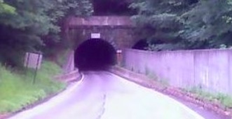
I saw a tunnel and went through it under the Horseshoe Curve. On the other side was a beautiful forested country road. I kept riding and it kept going up. And that was the new deal I made with myself. As long as the road turned up, I would keep riding.

I saw a sign for Adopt a Highway and saw it was sponsored by Blair Co. Bicycle Club for the next four miles. I figured I had four miles. Cool.
After about three more miles I was getting tired. I was in my granny gear and was standing and sweating. But I kept moving without “paperboying” back and forth across the road to make the grade a little easier. Finally, it became easier.
I read later that this section is 10-12% but then one hits the wall at a 19% grade for a half mile before settling back to 12% for the last mile. That was it. And I made it. I love riding in these mountains.
I turned around. On the descent, I wanted to let it out. But this road had many curves and it was raining. The rain was following me. The last speed I saw was 43 mph in a curve. Then my computer went out. On the transmitter, a support broke off so it wasn’t in the right position to read the magnet on the spoke. I was doing 0 then 10 then 6 then 4 then 38.
I will need to come back and explore this more. Much more. It was everything as advertised especially “three lakes and a 200′ tunnel.” It is absolutely beautiful.

