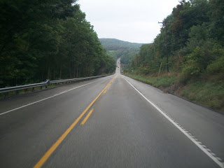
Road Dirt and Fog

FRIEDENS, PENNSYLVANIA

After two days of driving from Key West to Baltimore then to Somerset, Pa., I was ready for a nice ride. Maybe not this one but it’s the ride I got.

I have driven the mountain up westbound on US Rte 30 from Shellsburg towards Stoystown probably more than 100 times and always wanted to bike up it. A nice little climb it’s a two-lane road with a little bit of a shoulder. Safe enough.

I left my parents’ place and rode into Somerset, fueling (eating) at Sheetz. Then I headed east on PA 31. The rode has narrow shoulders and lots of coal truck traffic. But generally the coal trucks gave me wide berth – it was the regular pickup truck drivers who made no attempt to go wide even when no cars were approaching.

The weather was about 50 degrees and a mist from the fog hung over the area. The first 20 miles featured some nice rollers on the Allegheny Plateau. Crossing the Allegheny Mountain I pedaled hard trying to hit a good speed. Only when the road flattened out did I check to see my high speed — 50 mph.

Anytime I hit 50 mph it’s going to be a good day on the bike. I descended to the valley floor then navigated by feel. I knew where I could go to get to Shellsburg but took a chance on a road before Manns Choice. I guessed right.

In my mind I was going to go farther – over to Rte 96 and past Shawnee State Park to Shellsburg but I was also planning to meet my sister, Betsy, for lunch. So a 50+ mile ride made more sense than a 60+ mile ride. I found Buena Road which cuts over to Rte 30 near the Buffalo Farm.

Coming out on US 30 I turned left and started up the mountain. I always wanted to ride up US 30 but in better conditions. It was foggy and visibility was low. Winter dirt was still on the shoulders. Here they use a mix of of salt and black cinders to treat the roads. Combined with the mist and fog, it made for a wet mix on the bike.

I began the six mile climb and enjoyed every pedal stroke. I only wish I could see. Visibility was so poor near the summit I could hear a car approaching before I could see its head lights. I was hoping that no car would come flying up behind me. But none did. And over the six miles only 20 cars passed me on the climb.

On a clear day it is advertised that one can see three states and seven counties. But today I could barely see 100 yards. I passed the remains of the Ship Hotel, a travel icon in the 1930s.

I continued on “Seven Mile Stretch” and reflected that three days ago I was riding Seven Mile Bridge. What a difference. Unrelenting sunshine. Views that went forever. Here? Not so much.

I passed the entrance to the Flight 93 Memorial then continued to Stoystown before heading back to Friedens. It was a dirty, chilly and wet day but was still a good 54 mile day on the bike. 

A Quest for 50

PAVIA, PENNSYLVANIA

Back on roads safely away from vicious man and dog-eating dogs, I decided I would try to hit 50 mph today. On US Rte 30, two miles west of Stoystown, Pa. is an awesome steep hill which is straight as an arrow, hits a dip in the bottom and goes straight up the other side. In other words, a perfect hill to gain speed. No worries about curves or stopping.

US Rte 30 looking east. The grade is longer on this side but steeper on the other side.

I parked at the bottom of the hill and started my one mile ascent up the 7% grade. Much of this climb was 10-11% but there is a 5-6% section in the middle which brings the average down.

At the top I turned around, put the bike in the big gear, and pedaled as fast as I could. I got in my aero tuck and watched the speedometer creep up – to just 45 mph. I was disappointed.

I rode through the dip at the bottom of the hill and began my climb up the other side. The total climb was 0.7 mile but the steepest section was near the bottom – the last 0.4 mile. In this section the road averaged 10% grade.

Though I went all the way to the top and turned around to try it again, my speed didn’t really creep up until I hit the bottom ramp. My Trek computer had me at 49.2. Close, but not quite 50. I will have to try again next week.

After a few minutes, I decided I would head over to Altoona, mainly to ride Horseshoe Curve. But when I reached Summerhill (yesterday, by bike) and saw the sign for Blue Knob State Park, I decided to follow the sign.

I parked at the park entrance and began the 4.5 mile climb to the summit. Many sections were hitting 14-15% and 16% in the last section. It was a nice workout.


There are no roads like Mount Washington but climbs like Blue Knob are helpful. Glad I came back, even if for a day.

Garmin Map and Stats – Rte 30

Garmin Map and Stats – Blue Knob

UPDATE: There will be no try next week. I have changed the gearing on my bike to ready myself for Mount Washington and have removed the “big ring” necessary to hit top speed.

Verified by MonsterInsights