IDAHO SPRINGS, COLORADO
It was difficult finding a place to rent a good road bike in Denver but I settled on 240 Ski and Bike in Idaho Springs. They didn’t have a true road bike but they basically had road bikes with straight, not drop-down, handlebars. I drove out I-70 to Exit 240 at Idaho Springs and was there by 8:15 a.m.
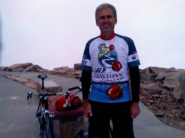
It was a beautiful morning and just a little cool. A great day for riding. The temperature was maybe around 60°. I wore a long-sleeve Under Armour base layer (cold) then my Mt Washington/Newton’s Revenge jersey. Bike shorts.
We had to agree on terms for the bike. A decent time to the summit, according to Bicycling magazine was 3.5 hours. Of course, there’s the ride back too. The salesman at the shop looked at me and said “You look like you’re in good shape so you should be able to do it in a decent time. I’ll put you down for five hours and call it four.”
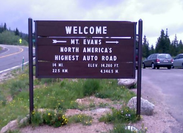
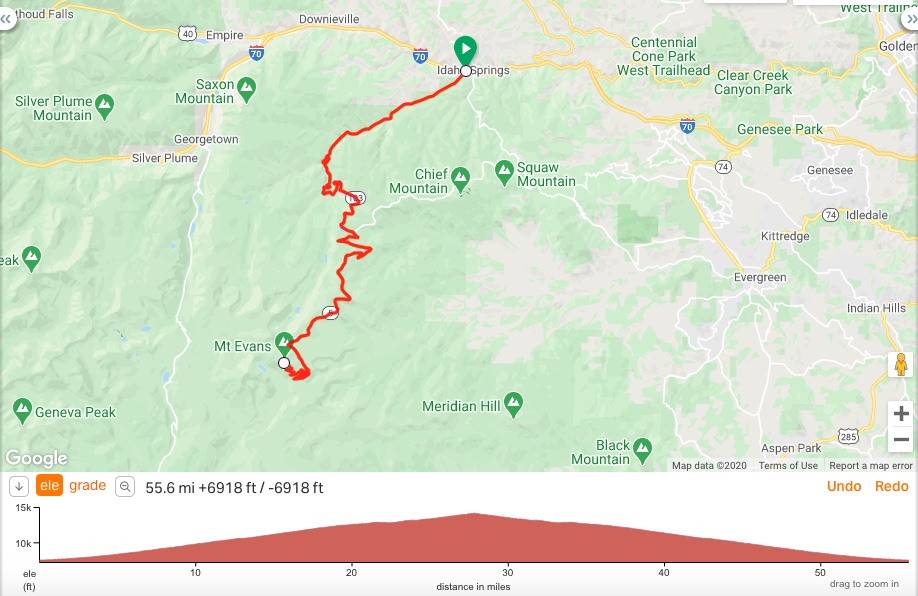
I left Idaho Springs for what was to be a straight shot to Mt. Evans. I wasn’t sure how far it was and stupidly, was afraid to ask. I had read 28 miles but wasn’t sure if that was one-way or round trip. I also read it was 14 miles. Of course, it’s both, depending on whether you start at Idaho Springs or at Echo Lake.
As soon as I left Idaho Springs I crossed I-70 and immediately began climbing. I saw a sign for Mt Evans Fee Area – 14 Miles and hoped that it was 14 miles to the top of Mt. Evans. I pictured a plateau and even thought that perhaps the road continued down the other side. I was so ignorant.
The road up started pretty easy, especially the first six miles. Unfortunately, there are no elevation markers except at the major mileposts. I think I would have liked to know every time I went through another 1000 feet. There were no flats for the next 14 miles.
The route was through Arapaho National Forest and was absolutely gorgeous. I thought many times about stopping to take photos. But wanting to make good time and the absence of a good camera made me soldier on. I had just two bottles of water with me and every mile when I saw the mile marker I took a drink as I tried to ration the water I had with me. I wasn’t sure if I was climbing 14 or 28 miles and that affected how, and when, I drank.
Mostly when I ride I catch other cyclists and the few times I am passed it can be demoralizing. Around the seven-mile marker, I was passed by a cyclist. Then around Mile 10, I was passed by two more guys. This was getting old. They were seemingly telling me how old I was.
I didn’t have a computer on the bike but had started my watch. I had started at a 5-minute/mile pace (12 mph) but did not expect to maintain that as the grade increased and the air got thinner. The elevation at the start in Idaho Springs was 7,524 feet (2,293 meters).
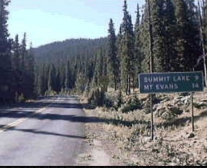
At Mile 14 I reached Echo Lake. Here the road parallels the lake for a quarter-mile and is dead flat. The flat pedaling was a welcome relief. It was an accomplishment to reach Echo Lake and the entrance to Mt Evans. Here also was Echo Lake Lodge. And store.
I caught the two cyclists who passed me as they had stopped for a rest. I borrowed an Allen key to lower my seat. It had been too high which prevented me from getting into a good cycling rhythm. I also learned that they were with a group and were the only two who could go off the front. The rest couldn’t keep up with them so at least the group didn’t pass me.
I went into the store and bought another bottle of water for the next 14 miles — to the summit of Mt. Evans. This would be the only stop I would make and I wouldn’t call it a rest stop. It was necessary to adjust my seat and get more water. Total time off the bike was only three minutes. Riding time to the lodge had been 99 minutes.
I left the lodge, started towards Mt. Evans, and immediately came to the main entrance. I was prepared to beg my way out of the three-dollar entrance fee for having “suffered enough already.” Indeed, I had told the other cyclists that I read one could beg their way out of the fee by stating that you were only riding to the summit then turning around and coming right back. I didn’t have to. The ranger said he could waive the fee if I told him I was going to ride the summit and then immediately come back down. I assured him I was.
Almost immediately the road turned up. There are two quick switchbacks then another two in about one mile. But then the road straightened out quite a bit until the final ascent.
Ahead on the first switchback, I saw two riders. By the time I rounded the switchback, I saw just one remaining with a rider much further up the road. I finally caught someone! I slowed as I passed trying to make conversation. This gentleman was from Evergreen, Colorado and it was clear he was going too slow for my pace. I was on pace for a three-and-a-half-hour climb and didn’t want it to take longer. Plus I knew the road would turn up in anger later.
In a few more minutes I caught the second rider. And we began to ride together for a while. At a certain grade, we seemed to have the same pace. But on a lesser grade, maybe 3-4%, he seemed to be a little stronger. When the road turned up I would pass him. We didn’t discuss it but we took turns leading each other. And it worked.
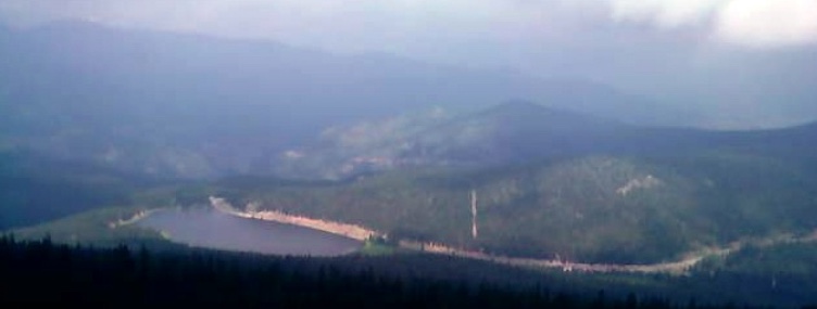
Somewhere about four miles into this road we passed the tree line and entered a treeless alpine environment. For those miles, we stayed with one another. Around Mile 10 (24 total) we reached Summit Lake (12,830′ or 3,911 meters) and here the road turned down. It was paved but very rough. My new friend knew the road and took off down it. I struggled to keep up. It wasn’t steep but a gentle downgrade although the road was rough. Winter freezing plus spring thawing and refreezing had buckled the road in many places and left potholes in others. I didn’t want to crash out being stupid.
After passing Summit Lake we started climbing the final section of the day. Only 1400 more feet (427 meters) of climbing. By my calculations, the grade kicked up to 9-10%. Here the switchbacks start in earnest. I think there were 14 of them. I went ahead of my new cycling friend. I saw him as we turned the next couple of switchbacks but after a while lost contact. I don’t think that either he or his friend made it to the top.
I kept climbing higher. The switchbacks kept getting closer, maybe 200 yards or so between each turn and the grade seemed to increase with each one. I was trying to keep a steady rhythm as I pedaled but the legs were burning and sometimes it felt better to switch to a bigger gear and stand. But as I did I noticed that I no longer could stand long without getting light-headed or dizzy. Best to sit on the seat and tap away.
It was painful but always a good pain. Physically. Mentally it was tough because it was easy enough to turn around. I tried to focus no more than 100 yards ahead. Once above the tree line you can see that road climbing forever. If you allow yourself to look too far ahead surely you will want to quit.
I did frequently look back at the road just traveled. When I looked next to see if I could find my cycling partner I saw another cyclist. And he was slowly gaining on me. Except when he caught me, he was a she and she pedaled right by me. That was enough to defeat me. But it didn’t. I figured that I would do this ride once in my life and may as well dig deep to find the energy to continue.
I kept banging through the switchbacks, and getting close to the summit, saw a mountain goat. I wasn’t about to stop and take a picture because I don’t know if I would have got going again. But a car was about 25 yards behind me and I pointed to the goat. They stopped to take pictures.
I had a hard time determining where the climb ended. It just seemed to climb forever. Each time I made a turn I hoped I could see the top but when I looked up, always a bad idea, there seemed to be more road as far as I could see. But when I looked again I could see more switchbacks but this time they were crowded with people walking. No cars. No bikes.
I was there. I rounded one more switchback and could see the small parking lot. I found the energy for a sprint if you could call it that. Out of the saddle, I pedaled hard for the last 50 yards. Then I coasted home in the parking lot.
I pulled in and talked with the young lady who passed me a few minutes earlier. She is from Colorado and rides for Whitman College (Washington). I think living at altitude helps and so does being young. She said it doesn’t help but she will understand in about 30 years. It helps.
(Note: Upon returning home I Googled Whitman College only to discover that Whitman women won the NCAA Div. II national title in 2005 and 2006 and finished third in 2007. No wonder I got smoked although it wasn’t that bad. One of their riders, Mara Abbott, just won the USA Cycling National Road Championship at Seven Springs.)
I dismounted and immediately became dizzy and looked for a place to sit. I can say that climbing at altitude was no problem for the lungs. Can’t say that they were burning nor that I was gasping for breath. I think I held something back from my effort all day as I wasn’t about to give 100% effort (sprint) then not have anything left. I didn’t know how much to ration so I kept the steady pace going during the climb. But I never felt sick or out of breath. Cramping was never an issue so my hydration plan was at least adequate. But I was very lightheaded once I was walking.
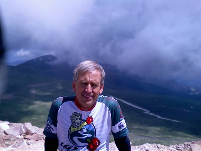
I sat down and took in the view. Probably could see for 50 miles although that view lasted about three minutes. Out of nowhere, a cloud moved in and all of a sudden one could see about 50 feet and that was it. And the temperature dropped as well. The temperature was in the low 40s when I arrived at the summit but quickly dropped when the clouds moved in.
Most cyclists had jackets on as they descended and I had brought my cold-weather gear. I was surprised that my jersey was wet with sweat since I never felt sweat dripping off my face or arms. But I had worked hard and knew it was time to put my jacket on. And after no more than five minutes resting it was time to descend.
While I had started my stopwatch and looked at it climbing to Echo Lake, I forgot to look at it again to measure total time to the summit. I thought it was about 3:45 but I reset it to zero to clock the time back to Idaho Springs.
I looked forward to what could be a 28.5 mile descent coasting all the way. But my body was tired and aching from the climb and the thought of throwing my bike in the back of someone’s pickup truck was even more inviting. But there were no offers.
I headed down 50 yards to the first switchback, turned then went another 100 yards and knew it was cold. Temperatures may have been in the high 30s. I pulled over and pulled on my leg warmers and went to the full-finger gloves. When I restarted I quickly started following a car descending and had to brake for him as he was cautious. For a lightheaded cyclist, which I still was, it was much safer to follow someone who was being reasonable. When the body is tired is when one loses focus and makes stupid decisions, sometimes tragic.
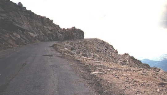
The drops off Mt. Evans were huge. There are no guard rails the entire way and in some sections, even the roadway had buckled and dropped off. If one were to ride too close to the side of the road, despite pleas from ignorant drivers to do just that, it would be too easy to hit a section of road that simply disappeared. And so would the cyclist. My focus was 100% on the road and I never looked down at the large drops I was riding next to. To look down would make me dizzier.
And I was cold. My legs were shivering uncontrollably and so were my arms. My chest was tight as I was fending off the cold. I knew this was the beginning of hypothermia. I wanted to go faster to get off the mountain as quickly as I could but also knew the faster I went the colder it was.
I followed the car to Summit Lake where the road becomes somewhat straight for one mile. Even if one could coast through this section one had to be very diligent in watching the road hazards. But passing Summit Lake this road has a rise to it for about a mile. I reached down for energy to pedal some more and it was very difficult. But I knew that I would only have to get past this section before beginning my descent the rest of the way.
I think there was yet another section to climb, not difficult mind you, just a pain in the butt and legs after all the earlier climbs. But once I passed it I was out of most of the switchbacks and on better road. I switched into a bigger gear and started pedaling. I had shaken the extreme cold and wanted to go fast — as fast as I safely could that is.
While I was pedaling I allowed myself to be caught by two guys descending. Whether or not they were the two that passed me going up, I don’t know. I didn’t see them at the top. I didn’t have a road bike with 23cc tires and couldn’t descend quite as fast. I was descending about 40 mph and they were going a couple of mph faster. As they passed I picked up my pace and followed their line. I figured they knew the road and how fast they could safely take the turns. It helped following them. My total time descending back to Echo Lake was 42 minutes which included the slow sections at the top and the climb by Summit Lake.
My pacers pulled off and went into the lodge. I started the descent past Echo Lake then down to Idaho Springs. This truly was downhill and while one could presumably never turn a pedal the entire way the speed couldn’t have been that great either. There were technical turns that I had to slow down for but I was still moving at a 30 mph pace. How do I know that? I was timing the miles as they were ticking away at two minutes every mile.
It hurt to pedal but I wanted to get off the bike as soon as I could. I missed my Trek Pilot carbon bike and could feel every bump this aluminum Scott bike hit. I kept the pace up celebrating every time I passed another mile marker sign. There was another reason to hurry back. It was raining too. Lightly, but still raining.
Mile Marker One went whizzing by and I could see Idaho Springs ahead. It was easy to find the last remaining energy to pedal across I-70 and into the parking lot at the bike/ski rental store. I had rented the bike for four hours and although I was outside the four hours the manager graciously told me I didn’t owe him a thing more.
I thought about what I had accomplished. Mt. Evans. For some, one of the holy grails in cycling, at least in the U.S. The highest paved road in the country. Very high altitude. Although I was passed on the climb by some cyclists, the only people who succeeded at this climb are incredibly fit and are true cyclists. And I think everyone was younger than me. While there may have been four that passed me on the way up, that was four in 28 miles and all were in great shape. And did I mention young?
I immediately said to myself “Never again.” I accomplished it and don’t need to try it again. However, I wouldn’t rule it out either. I don’t think I would plan a trip to Denver to ride Mt. Evans but if I was in the area again, who knows?
Reminds me of the time my wife tricked me into driving Trail Ridge Road in Estes Park Colorado. I think she wanted to do me in. As I inched higher and higher past the tree line, the switch backs with no guard rail gave me panic attacks. A look off the edge of the road was a look into infinity. We got to the top and I smoked the brakes all the way down, moving one inch at a time and keeping the center of the car hood on the center of the road. Didn't make many people happy. Ran a biker off the edge, who sorta looks like you. Not sure. Avis had to do a brake job. I did not live to tell about it.
Ron C.