MS-150

STATE COLLEGE, PENNSYLVANIA

A Tale of Five Segments

First, they had plenty of bibs “I Ride For…” at the start. I had made one ahead of time for Bethany and added one for Kristi Wallace and Kayla Bracken. I was the only one I saw wearing a bib and no one asked me about my daughter from seeing it.

My Bibs for the weekend

SEGMENT ONE – Hollidaysburg to Roaring Spring (19 miles)

I rolled out in the front group. I don’t know if it was the first 100 (ish) or the entire ride. I settled in and we dropped some slow riders but were going at a steady pace. Each time the group was splitting, usually on a hill, I was able to stay with the front group.

Riders at the start

Two riders wearing kits from Spokes and Skis (a sponsor) joined us. I recognized one as Bryan Caporuscio, the owner. It was six years ago I jumped into their group ride and when I asked “Bryan?” he said “Barry!” He had remembered me from that one brief half-ride. I knew that he and his friend, Jeff, would be looking to hammer it today. They moved towards the front but I stayed with them until they caused a split. I was too far back to try to bridge, nor was I up to the effort it would take.

In the group on Reservoir Road

I did find myself at the front of the main group and stayed there until finding a train station in Roaring Spring. It is a ride, not a race, and I went off the front then stopped and grabbed my photo. I was happy I stayed with the group all the way to the first stop until the photo.

My train station photo in Roaring Spring

SEGMENT TWO – Roaring Spring to Williamsburg (15 miles)

I rolled out alone (I rolled out of every stop alone today except for the mass start) and caught seven riders in Martinsburg. I sat on the back for a while. It appeared three (wearing yellow/white) were working and four (wearing blue and black and green) were getting a free ride.

Ritcheys – First Rest Stop

I moved to the front and helped work. In fact, I was afraid I rode them off my wheel but after two miles I discovered they were with me. So now there were four of us. I took my turn until, a photo. Again, I went off the front, exited safely, and went back for the picture.

Martinsburg, Pa. – The blue jerseys are from OMBO – Old Men on Bikes

Back on the road a group (with momentum) passed me. I joined them, eventually went to the front and dropped them. Damn me.

Worth a photo

SEGMENT THREE – Williamsburg to Camp Kanesatake (17 miles)

I rolled out alone. The yellow/white group had grown and looked like they were ready to roll. I decided to soft pedal until they caught me then I would join them. They went by and it appeared there were 15 of them plus about five others. I jumped in.

Rest Two – Williamsburg, Pa.

We got blown apart on the first big climb, and I stayed with their three leaders. I found they were not a friendly bunch, at least to this stranger, I eventually let them go and the remnants of their original group came by. I jumped in. I moved to the front to Camp Kanesatake for lunch.

Lunch was at the camp. I got the feeling I was the only one on the ride that wasn’t riding with a friend or partner. I sat with some volunteers. A couple of the white/yellow group had rolled out and when lunch was over, I took off.

Camp Kanesatake is a Christian church camp located in Spruce Creek, Pa.

SEGMENT FOUR – Camp Kanesatake to the famous Cookie Stop (14 miles)

I cleaned up my trash and looked around. It did not appear anyone was leaving that I could join so I took off. My plan was to soft pedal until the group caught me then join them. Here is where two competing aspects of my brain kicked in.

Maze Church, Warriors Mark, Pa.

Logical Brain: Soft pedal and they will catch you and you can ride with them

Macho Brain: Don’t let them catch you. You are better than them.

Logical Brain: Let them catch you – you can save 30% of your energy by sitting in the group instead of riding alone

Macho Brain: Don’t you dare let them catch you. Hammer it!

Macho Brain won. Sigh. It’s a struggle I often have.

Camp Kanesatake

It was 15 miles and I did not want to get caught. In fact, I ended up catching two riders who had left about five minutes before me. And then was able to enjoy the famous cookie stop. (Truth: I had one chocolate chip cookie given to me by a young girl whose mother had baked it.)

The traditional cookie stop, the parishioners are all in at Halfmoom Christian Fellowship Church, Port Matilda, Pa.

SEGMENT FIVE – Cookie stop to State College (13 miles)

I stopped to talk to the volunteers at the entrance/exit and the four young kids. I left the message with the kids to always wear a helmet when they ride. In the meantime, a group of five or six guys took off. They were one minute up the road.

Beaver Stadium, State College, Pa.

I thought about going full in to try to catch their group but decided to ride my own pace. Their group dropped two (blue riders) and I had them in sight. For a couple of miles I could see I was 35 seconds behind. And then it came down quickly. Twenty seconds. Ten seconds. And a catch. I joined them, stayed with them for about a minute, then went to the front to work. I dropped them. Rode solo to the Penn Stater.

The finish line at the Penn Stater

I beat the rain although it doesn’t look I will be so fortunate tomorrow. This was my longest ride of the year, derailed first by knee replacement and then by a memory-loss crash and concussion. So I am happy. Very happy.


Tour de Indiana

INDIANA, PENNSYLVANIA

No, not Hooisers. But Indiana, Pa. Home of Jimmy Stewart of 1940s-50s movie fame.

Downtown Indiana, Pa.

I had gone online, found four covered bridges, and then using RideWithGPS.com, mapped a 35 mile ride which would take me to the four bridges. Today was a great day to ride.

Downtown Indiana

I parked at the Indiana Mall and then took Rte 286 (Oakland Avenue to Philadelphia Avenue) out through town. Indiana has a beautiful downtown, even prettier in the early morning sunlight.

Kintersburg Bridge

The first 8.5 miles, towards Clymer, was on Pa. Rte. 286. It was sketchy at times. Not a major highway but it is the major road between Indiana and Clymer. Despite a 4-foot law, some cars came much closer when passing, the closest of which was a Pennsylvania State Policeman. Seriously.

Barn on Tanoma Road

When I turned on Rayne Church Road I was glad to be on a country road and stay on country roads the rest of the ride. I first came to the Kintersburg Bridge which surprised me. I was enjoying the day and temporarily, had forgotten this was a covered bridge ride.

Yes, I was almost to Home

I passed the most beautiful farmhouse (but did not take a picture) next to a pretty barn. I hesitated turning onto U.S. Rte 119 but was on it for less than .25 mile and saw no cars on it for the 1:00 or so I was there.

Crossing the Buffalo and Pittsburgh Railroad

What I didn’t know: Rte 119 is also marked as Pittsburgh-Buffalo Road. I turned onto Chambersville Road and came upon three at grade crossings with a railroad. None had any signals, just a “Railroad” sign.

Gravel on Black Road

I didn’t see the railroad but I am 99% sure the single track belonged to the Pittsburgh and Buffalo Railroad. This would be the line from Punxsutawney to Homer City, a line which goes past my uncle, Don Sherry’s house in Juneau.

Black Road. Downhill.

I didn’t know where I was going (which was part of the fun of this type of ride). I was following my Garmin cues when it told me to turn left (Black Road). I turned and after 75 yards it turned to gravel. I stopped. I thought I could check where I was on Maps but was in a no service area. I decided to push on.

Looks like red dog under the surface

It was rough riding. It wasn’t impossibly hard but I was worried for the bike and wheels. At the top of the first climb I had a great view and saw the road continued as gravel. I walked. I did not want to be on the bike on a steep descent as I was afraid I might slide out.

Harmon’s Bridge

Although it felt like four miles, it was two miles. The road appeared to be an old “red dog” road (mine waste). These were supposed to be removed years ago and it appeared to my eyes that this was not fully removed.

Trusal Covered Bridge. I rode in the field instead of the gravel.

I came upon the second bridge, the Harmon’s Bridge.  Shortly after seeing this bridge I jumped on Five Points Road. If I had stayed on Davis Road instead of turning onto the gravel, I would have come to Five Points Road. In fact, it was probably the same distance. But when I mapped it out I chose the route because I wanted to ride over the bridge and not divert from my route (Five Points Road). If I did this again, it’s an easy change to the route.

Trusal Covered Bridge

Only half mile away was the Trusal Bridge. It was also off Five Points Road. The road to the bridge was gravel. I chose to ride in a field next to the road rather than on the road.

Bridge under B&P RR

I rode to Creekside and over to the Thomas Bridge. As I left Thomas Bridge, Garmin had me going up Jamison Road. It turned to gravel. I turned around. I rerouted over to Fleming Road. I got on N. Ben Franklin Road and had my biggest climb of the day.

Thomas Bridge

Partway up I saw what I thought was a sleeve of drill bits. I stopped, picked them up, and saw they weren’t drill bits. Later I posted a photo of them on Facebook and offered them to anyone who wanted them. Guesses were calligraphy tips, leather punches (and there are Amish in the area), and tattoo needle guides. The winner was tattoo needle guides. I discarded them.

Tattoo needle guides

If I ride this again, I would look for an alternative to 286 towards Clymer, stay on Davis Road to Five Points Road, and erase Jamison Road which I did as I rode. And I may ride it clockwise to get the Ben Franklin road climb out of the way at the beginning.


Covered Bridge Facts

  • Harmon Bridge, which was built in 1910 at a cost of $525, is 45 feet long and was named after Civil War veteran J.S. Harmon
  • Kintersburg Bridge was built in 1877 and named for Isaac Kinter, a local shopkeeper. J.S. Fleming erected the bridge over Crooked Creek at a cost of $893.
  • The Thomas Bridge was built in 1879 at a cost of $545 and completely reconstructed in 1998 at a cost of slightly more than $1 million dollars.
  • Trusal Bridge, built in 1870 (also known as Dice’s Bridge). At 41 feet long, the Trusal Bridge is the shortest of Indiana County’s covered bridges. It was named after Robert Trusal, a nearby property owner. The preceding facts and more information can be found at the Indiana County tourism website.

Southern Walnut Creek Trail

AUSTIN, TEXAS

I began the day at Bicycle World in Austin. Here is one thing to know when visiting Austin: There is no such thing as a free lunch and there is no such thing as free parking. Well, maybe that’s two things.

Inside Mellow Johnny’s

I found a parking lot next to Bicycle World with very imposing signs – “We Tow. We have cameras.” I didn’t park there. Not even sure what kind of lot it was. It may have been for a hamburger place. But it wasn’t friendly.

Ridden by Lance Armstrong in 2001

Instead Schlotsky’s Deli is right across the street. Imposing signs there too – “Parking for Customers Only.” But I went in, enjoyed a sandwich and a drink, then ran across the street to Bicycle World where I checked in for tomorrow’s Atlas Ride. I noticed they had a sign for bicycle rentals and thought maybe I should have gone there. Or maybe next time.

“The Look” – Notice the Juan Pelota Cafe cap. Pelota is Spanish for ball; Juan sounds like One

After checking in and going back to the Schlotsky’s parking lot, where my rental car had not been towed or booted, I drove over to Mellow Johnny’s. There is a parking lot for Mellow Johnny’s. But a couple years ago, the city noticed somehow MJ’s customers were allowed to shop without paying the city. So they put an end to that. This is Austin.

Imposing sign – You Must Pay to Shop here. I went to the pay kiosk, registered my car. Parking was $2 for one hour; $9 for two hours. I wonder what what happen if after 59 minutes, or 60, one would go back and pay for a second hour of parking. This city needs some grown ups in charge.

Southern Walnut Creek

I went in and re-introduced myself to Peter Finklea, the rentals manager at MJ’s. This was the third or fourth time I rented here. Peter is a very nice guy and I have really enjoyed renting bikes here in the past. This one was a last-minute decision.

I had budgeted $50 /day for a quality bike rental. I thought I would ride some on Thursday when I arrived, plus Friday, and of course, the Atlas ride on Saturday and something, somewhere on Sunday.

Southern Walnut Creek Trail

Never one to get anxious, I think I was being affected by the concussion I sustained in Ohio. The thought of tearing down my bike, delicately packing it, then flying with it was weighing on my mind. And there is the cost component. The “full fare” airlines charge $150 to check your bike as luggage. In a bike crate or bag. Each way. So flying my preferred airline, American Airlines, was basically out of the question from the start. I booked on Southwest Airlines because their bike fee was friendlier – $75 each way.

Southern Walnut Creek Trail

Without considering the hassle of tearing down the bike, rebuilding it at the destination, and worrying about whether it will make it undamaged, just the cost factor meant a 3-day rental was the same price as taking my bike. Then will I want my bike? For 100 miles, the answer is probably yes. For extreme climbing, the answer is definitely yes. But for 50 miles without a significant climb, it really didn’t matter. So I went online and found my size and reserved at Mellow Johnny’s.

Southern Walnut Creek Trail

Peter knows what he’s doing. He did a quick but thorough bike fit – as much as one can do for someone about to go out the door on a rental bike. He adjusted the seat, twice. The stem and handlebars were OK. He affixed the computer mount that I just bought and I asked him for a recommendation of a ride.

Southern Walnut Creek Trail

Unlike past years where it was OK to leave the car in the MJ’s parking lot and go ride, I had to be gone by 12:53 p.m. Peter offered up “hilly and long” to the west and “shorter and flatter” to the east. With the temperature pushing 100 degrees, I opted for shorter, and flatter.

Southern Walnut Creek Trail

Although Peter pulled out a map, he talked about the Southern Walnut Creek Trail and I realized that I had ridden it before. And it would be perfect. After figuring out it didn’t start at “Go-Valley” Park (but Govalle), I drove out to the park.

Southern Walnut Creek Trail

The Southern Walnut Creek Path is relatively new. It is a 10’ (3 meters) wide concrete trail. And I saw virtually no one other than a family walking their dogs at the beginning. Peter had said the trail was 10 miles and I had remembered a plateau after eight miles or so and then a descent across a road. I had decided that I would ride to the plateau but not the descent. I was afraid of going too far and I didn’t want to ride the descent knowing I’d have to turn around and come back up.

Southern Walnut Creek Trail

Strange it seems. I love to ride and I can go 100 miles or more with no problems. But with knee surgery and a long recovery in February, I was just starting to get outside on the bike. The trip to Ohio was to get in some long miles but that didn’t work out. Actually, I got some of the miles I wanted but was planning another long ride on my day home. That ended with the concussion.

Southern Walnut Creek Trail

Now I worried about getting light headed. Running out of water. Or simply going too far for too long in this heat. So twenty miles would be enough.

Southern Walnut Creek Trail

At the plateau it was windy. Here the trail left nature behind and passed a trailer park that seemed to go on for a mile. My memory from a couple years ago worked fine. I came to the road where the trail turned down and decided to go back. I knew I would get 20 miles just out and back and decided to explore some of the spurs.

Southern Walnut Creek Trail

Or I explored one. At least. There was a half mile trail to the Austin Tennis Center. I arrived and saw all these empty courts. No one was playing. It was 2:00 p.m. on a Friday and it was 100 degrees. Couldn’t blame them. (Or maybe it wasn’t open weekdays until the evening.)

Southern Walnut Creek Trail – Hot and WIndy

Getting back to the car, I was hot and thirsty. I had used my one water bottle and did the only thing I knew to do over the next three days or so. Find an In-N-Out Burger. Although this would be simply for replenishment (milkshake) as I was headed farther north for the night.

The Year in Review – 2017

Other years I have listed my 10 most memorable rides. I thought I would do it differently this time and not concentrate on rides but experiences.

Most American Looking Foreigner – On the ferry from Gertau to Beckenreid, I met a 30ish woman. She was wearing a Specialized (American Co.) kit. She was on a Cervelo (Canadian) bike. She had a Garmin (American) 510 bike computer. She was wearing Speedplay (American) walkable cleats. But she was Swiss. Lived just up the road and had completed a Luzerne loop. I told her my suspicions which she found very interesting and not creepy at all.

Biggest Douchbag – The sidewalk cop in Zurich. In a city where bike paths and sidewalks are all asphalt and bike lanes are directed up on sidewalks, I got caught on a sidewalk, sans people, in an area then Ben would later find was a cyclist trap. The cop did not care that I was from out of the country, in fact, I think he targeted my Austin (Livestrong) jersey. Didn’t record my name. Just wanted 40 Swiss francs.

Best Ride in a Circle – Our annual trip to the Velodrome at Trexlertown, to honor pediatric cancer survivors and we too, could take a lap against cancer.

Most Wheel Problems – Broke a spoke on my rear wheel on my Domane. Had all the spokes replaced and a new wheel built. The new wheel seemingly went out of true and it took 2-3 trips to get it tuned in. But it ate tubes. Two in one mile on a ride in Bedford Co. Switched to my original wheel and it locked up. One week later while riding to Punxsutawney a piece of gravel (chip as in chip and tar) busted out my front spoke.

Favorite Day – Climbed the Klausen Pass then descended to the beautiful Lake Luzerne. The views were tremendous in the mountains and alongside the lake.

Best Hotel – Seehauser Hotel in Beckenreid, Switzerland. A beautiful room overlooking a breathtaking lake with mountains in the background. An excellent restaurant and wonder staff. Easily my favorite.

Shortest Country Visit – I biked from Switzerland into Austria long enough to find someone to take my photo. Still spent 20 minutes or so. Runner up: Germany – on a three country ride with Ben Z., our initial time in Germany was less than 10 minutes but then re-entered and spent 30 more minutes of riding.

Best Decision – At Hotel Rischli, I was given a pass to ride the tram to the top of the mountain. Too tired to use it (not wanting to go back up the mountain I rode down) I set it aside. In the morning I was all in and rode five miles back up the mountain to the tram and went to the top of the world. And discovered I had been here before.

Fastest River Ride –  Staying in Thun, Switzerland, I jumped in the River Aare and was swept away by its relaxingly fast current.

Sea Gull Century

SALISBURY, MARYLAND

Even taking 15-20 minutes to get ready at the car I was still wheels down two minutes before sunrise. It was a day to wear my rain jacket. Call it what you want, either a light rain or mist, but it was enough to make me wet and keep the roads wet.

I didn’t know anyone and was determined to ride alone. Although I hoped I would run into the contingent from the Blair Bicycle Club. I would follow the Assateague route, fully aware they had another one called Snow Hill. (I think.)

It rained (mist) for the first 90 minutes. Even if I wanted to jump in a pace line, wet roads and road spray convinced me not to.

I had a helmet sticker that wasn’t too sticky. In fact, I felt it come off just 5.5 miles into the ride. I felt bad about not stopping to pick it up (and I saw others) but I wasn’t in a position to do it safely. But then I came upon the “Beware of Walnuts” sign. There were two, actually, and I was prepared, almost, for a photo op. I safely maneuvered to a stop, turned around, and there on the road was a blinking rear light. I picked it up so that was a litter offset. Good find.

I came into the town of Snow Hill. It is a lovely town with its own lovely river (Pocomoke). The rivers on the eastern shore always fascinate me. The town was decorated for Halloween with a “scarecrow” on every block.

As much as I liked Snow Hill, I cursed myself for making a wrong turn. I was sure I was on the Snow Hill Century route. Any chance of running into friends was eliminated. Eventually I came to accept it and make the best of it. My two goals for the day were (1) don’t crash and (2) see some wild horses. Now I concentrated on not crashing.

Just four miles outside of Newark I came upon a sign which said Assateague – 22 Miles. I was on the right route after all. I perked up.

I continued to ride solo until Assateague with one exception. A huge group flew passed me. I bet there were 50-75 riders. I jumped in at the end. We were going 27-29 mph. Into the wind. I briefly thought about riding on their wheels but the roads were still wet although drying out. But I didn’t know about their bike handling skills. And honestly, this was not a free ride. My highest heart rate and highest speeds were recorded while I was riding with them.

I came to Assateague and found my horses. I was happy. I ate a banana and grabbed some Fig Newtons. I don’t get my money’s worth for these rides. I went past the first two without stopping and only ate a piece of fruit here.

I saw the group that I think I rode with. It looked like it swelled to 100 or more riders. Not for me. I had five guys pass me then I jumped in with them and rode to the next stop. (Potato chips). I briefly let them go when we came upon to riders who crashed by overlapping wheels in a group. At the rest stop I didn’t wait but continued on. I never saw those guys again. I’m not a fan of long rests at the rest stop.

Again, I was solo but eventually was caught but then joined a small group. We rode a comfortable pace to the finish. Well, almost comfortable. At the overpass over US 13 (Mile 100) I followed them right up to the top then a couple of them had a sprint to the end of the bridge. They gapped me at first and then I cramped. But I worked through it and stayed with them to the finish.

The arrival features an underpass and about 200 yards of sidewalk. A slow ride to the finish. It may have knocked down my average speed. Last year I averaged almost 17 mph. Even with the slow finish, I averaged 18 mph today. It was my fastest, and longest, ride of the year. And wettest too (I’ve been lucky.)


Cook Forest River Ride

COOKSBURG, PENNSYLVANIA

My fundraising for the Keystone Country MS-150 in July bagged me an unexpected bonus: Entry in the Cook Forest River Ride.

Disaster struck as I went to get dressed. I grabbed the only clean bib shorts I had and discovered they were the ones with knee covers. It was chilly but not enough for those.I thought about wearing a dirty pair but that would be gross. Better to be too warm. I had gone out to the car to check to make sure those were the only clean ones remaining on this trip. They were. My fashion choice also slowed me down on leaving the hotel.

Last night I checked the time and distance to the start and determined it was a 30 minute ride from the hotel. This morning it was a 42 minute ride. Not sure what happened but I came into Cook Forest running a little late.

I went to registration, passing my cousin, Kay Walborn, briefly saying hello. Got my swag (t-shirt) and took it back to the car. Riders were queued up. I went to the back of the group but lost Kay. I just couldn’t find her.

I started dead last then started making my way through a couple hundred riders trying to catch Kay. I stopped for a couple photo ops but generally kept going.

The course follows the Clarions River for 17 miles and some riders would do a 35 mile out-and-back. We turned across the river then started climbing. I saw a rider up the road and didn’t think I was gaining on him but eventually passed him. On the top I was by myself.

At Mile 30 I pulled into a rest station. And Kay was getting ready to roll out. She waited for me to grab some water and 1/2 banana. She was shocked I was behind her. She thought the entire time I had taken off ahead of her and she was trying to catch me.

We had been hammering the route trying to catch the other. We were probably never more than 3-4 minutes apart on the road at any time. We rode well together. I had a big advantage in going down hills (weight) while Kay had an advantage going up the steepest hills. One topped out at 22% according to my Garmin. I could not hold her wheel on that climb.

We passed a rider struggling and I told him he had just been passed by a 69 year old woman. She was kicking his butt. Mine too.

Back at Cook Forest they has served up a nice luncheon for us. We ate and then headed back home.  Not sure I would do this ride again but it was quite nice. And great weather today. Kay said that was a first.


My Past is Past

DAYTON, PENNSYLVANIA

This wasn’t the trip I planned but this was the trip I got. I drove to Dayton with the intent of doing a 30-35 mile loop around Mahoning Dam up to North Freedom.

I arrived in Dayton to begin my trip. I had preloaded a course on my Garmin and was determined to follow it. I went about 500 yards and turned onto a dirt road. Oh crap. Not sure how long I could do this. Thankfully it was less than a mile.

I followed my course for about four miles when Garmin told me to turn. It was a dirt road. I decided to forgo my plan and ride the “main” road. The main road was a chip and seal road. There were no flats. It was up and up again. Perhaps an occasional down hill. But not many.

I turned to go to Timblin, passing the farm of Scrap and Dot Snyder. Scrap is deceased but he was a classmate of my dad’s, and as I would discover later, 4th cousins.

Hard to imagine that 100 years ago this railroad town was a center of commerce. I stopped at the post office and talked to the postmaster, Stacey Taylor. She helped me with some of my roads. I had wanted to go up Brocious Road. I found the road, despite missing a sign, but found it was uphill, turned to gravel, and protected by angry dogs. I turned around.

I found my way to St. James Lutheran Church, founded by my great-great-great-grandfather in 1831. In 1989 I visited the church and was not greeted warmly as the locals were afraid my Uncle Tom Sherry and I were there to steal their pastor. We weren’t.

The church closed three years ago and Stacey told me the Lutherans tear down their closed churches rather than let them fall into disrepair. I didn’t have time to walk the entire cemetery but found some of my Sherry relatives. I actually meant relatives named Sherry because the cemetery is full of my relatives.

I left on my planned route and one mile later the road turned to gravel. Although I followed it for a bit, I turned back. I came to Shreckengost Road where I saw a teenage Amish girl. We talked for about 10 minutes. She helped me avoid gravel (go back the way you came).

I went to Ringgold then headed over to North Freedom. I passed Sherry Hollow Road. I understand my great-great-grandfather, Daniel Sherry’s brother, John Sherry, had his farm here.

We lived in the area from 1961-1964. My dad served four churches and I passed the North Freedom Church. I made my way to Salem, or New Salem, and saw the second church. In New Salem I attended a two-room schoolhouse for first and second grades (1-2 were in one room; 3-4 were in another). My teacher for first and second grade was Mrs. Shreckengost.

I left Salem and rode down to McWilliams. Then it was back towards Dayton. My legs were hurting.

I came to the crossroads. Here was Mt. Carmel E.U.B. church which may have close by 1968. It was the third of the four churches my dad served. A forest surrounded it and I thought about the Lutherans. How much better it might have been to simply tear it down.

The sign said Dayton – 8 miles. I knew my planned route was around the face of the Mahoning Dam. And I knew it would be 12 miles. I was very tired and was planning to ride the MS Ride tomorrow. I decided to go the short way.

I got back to Dayton and met a kindergarten teacher at Dayton Elementary School. The school opened in 1963 and we were bused from Salem to Dayton to attend this new school. It has been 54 years since I had been there. She was not impressed.

Back in Dayton, I met a kid on a bike. He wanted to race. He wasn’t wearing a helmet and I told him that I wouldn’t race unless he wore one. Deal breaker.

In a little over 30 miles I had climbed about 4500′. That was extremely mountainous. It was hot. I was toast.

That evening I met my 4th cousin, Jody Sherry Scott, in Clarion.  She told me her dad was born in McWilliams. We met at her frozen yogurt place in Clarion, Yo-Licious. I highly recommend it.


MS Day-2

HOLLIDAYSBURG, PENNSYLVANIA

It rained overnight and was very gray at rollout. But it wasn’t raining. I was hopeful we would stay dry. I lined up and they pulled the 100-rider rope right behind me. I was in the first group. But last.

99 riders in front of me

As we started out I moved closer and closer to the front and eventually settled in with a group of 10 which might have been the first group on the road. We worked well together although the hairy legged monster I was following scared me by occasionally just coasting causing me to brake.

Ahead I saw a tractor which I spotted yesterday. I told myself that today I would stop so I put up my hand and excited the pace line. I’m sure they thought I couldn’t hang. I could hang.

Once I took the picture I got back on the road and bridged up to a group of three and the four of us worked together to the first rest. It was quick. No mechanic (I was looking for a wrench) but my bottle was nearly empty. Refill then hit the road.

It started to rain. I didn’t get out the rain jacket and we rode for the next 20 minutes in a light rain although we had wet roads for the next hour.

Halfmoon Twp., Centre Co., Pa.

I rode this section solo although I hooked up with another rider. We rode side by side because even though he gave a nice draft he also gave a nice spray. I’m sure I did too.

There was an ice cream stop at Camp Kanesatake. Ice cream, at least mine, was served by Katherine Orczeck, the Blair Co. Dairy Princess (Alternate). When I told her mother I rode over Locke Mountain yesterday she said she cannot imagine. Her car barely gets over it.

At this rest I found the Spokes and Skis mechanic. I just wanted to borrow an Allen wrench to reposition my BarFly mount for the GPS. I had a multi-tool with me but it’s much easier to use a dedicated wrench. Fix completed.

Katherine Orczeck

Leaving Kanesatake, I was passed by two young men who were talking about how to work together. They thought they passed me for good but I blew by them just after Spruce Creek. One mentioned that we were leap frogging. No frogs here.

Sign seen near Arch Springs

At Arch Springs I stopped for a photo. They passed and then I followed them to the lunch stop. I soloed to Tyrone after a quick water stop. I was on my own.

Arch Springs

In Antis I was on a narrow street which has cars parked on both sides. There was not enough room in between for a car and a bike. There was room for a car or a bike (or two), but not both. I was in the lane when an SUV turned to come towards me.

I knew she didn’t have room but she insisted. She sheared off her passenger mirror. I chuckled. She saved two seconds which was the time it took me to pass the line of cars. But then she stopped to pick up mirror pieces.

After the Antis rest I saw a rider coming behind me. I slowed, thought he grabbed my wheel, then rode away from him. Geez.

I slowed again and waited for him and we rode together for about 6-7 miles until I rode away from him for good.

Arriving at the finish line in Hollidaysburg I checked the mileage and went for an out and back for another two miles. I caught the two young guys who were leap frogging me. I leaped them again.

At the finish there was a medal. A woman, confined to a wheelchair with MS, put the ribbon/medal over my head – a poignant reminder of why we Bike MS.


Out of Bibs

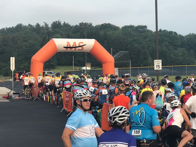
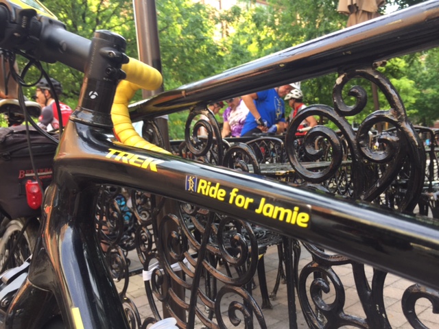
STATE COLLEGE, PENNSYLVANIA

I arrived for check-in for the MS-150 ride. I did not see then had to ask for a bib to make “I RIDE FOR…” I was told they sent their supplies to another event which did not return any. I was disappointed.

This is how we connect with people. I wanted very much to ride for my daughter, Bethany, Kayla Bracken, and Kristi Wallace. Seriously, how can they be out of the bibs? Press “Order Here.” Without the bibs it is just another group ride. I took out a Sharpie and wrote their names on my bib.

I was delayed. Two groups, supposedly of 100 riders each already left and it looked like ours was the last group.

What starting last looks like

I had been thinking about going over Locke Mountain instead of going to Roaring Spring with the group. Has I been in the front group, or second group, I may have rethought this. But I figured starting last or next to last, I would have to chase to catch the earlier groups to ride in a pace line. And since the pace lines would have already formed, I would be trying to bridge up to the pace lines.

Up Hill Drive. Made me giggle.

Still, I didn’t make the decision until I was on the road. I caught the tail end of the third group then, when it was safe, started to make my way through them. I had three decision points where I could make the move.

West Loop Road. I have no idea what this bicycle route is.

Coming off Frankstown Road was Locke Mountain Road. But there was construction and I wasn’t sure I could get there. Plus there were volunteers manning the intersection. I was past Tel Power Road before I even realized it. On Reservoir Road I continued to work through riders and may have caught some from the second group. As I signaled (bell) I was coming by I passed a guy and his wife. After I passed them I head him say “Wow!,” in apparent reference to my speed. I was doing 18 mph which isn’t exactly fast.

That probably cemented my decision. I really didn’t feel like hearing comments from riders as I passed them (although that may have been a compliment).

Looking out from near the top of Locke Mountain

I came to Loop Road, didn’t see any volunteers, and had gapped any riders behind me. I put out my left arm then turned on Loop Road. I didn’t want any volunteers to see me for fear they may chase me to tell me I was going the wrong way.

Trout Run where it enters Spruce Creek

The pavement on Loop Road was new asphalt. It was sweet riding. Apparently I was on a bike route – it appeared to have a clock tower although I haven’t figured out what it is or where it goes.

BBC Riders on the road

I came to Locke Mountain Road. It was all uphill from there. Most of the lower section, and indeed, most of the climb, showed 14-15% on my GPS. That may have been overstated though – it only felt like 12-13%. There were gnats around my eyes and I continually had to use a free hand to swat at them. Very annoying.

Lunch at Camp Kanesatake

I worked hard. I was soaked in sweat. On the descent I really couldn’t see clearly. Still I had a top speed of 45 mph.

Lunch at Camp Kanesatake

I followed some back roads to Williamsburg. I did not want to be the first rider at the second rest stop. I know there were some people hammering the course and I had cut 13 miles from it. Although I started much later than they did and had to get my fat butt over Locke Mountain I still felt it would be close.

Lunch at Camp Kanesatake

As I came to the end of Shortcut Road I saw a group of six go by. And they were apparently the first. I rolled in and spent a lot of time at Rest 2, mainly because I popped a lens out of my glasses trying to clean them.

Camp Kanesatake

I saw some riders from the Blair Bicycle Club roll in and reintroduced myself to Leslie, a woman I rode 100 miles with in October last year at the Sea Gull Century. They rolled out and I wasn’t too far behind them.

Disc golf at Camp Kanesatake

In addition to Leslie, I rode next to Aurora, another rider I rode with last year, although I did not recall her name (until referring to the entry from last year). I integrated with their group of five until we came to the first of the uphills. I pulled through with the intention of pulling but instead rode them of my wheel.

Volunteers thanking riders at the Cookie Stop

On US 22 I soft pedaled some, waiting from them to come back but they never did. I caught Pat, another BBC rider, on the run in to Spruce Creek. He too, was part of our century group from last year, although I forgot. We talked for a little bit but as the road went down I took off (serious descending advantage – see “fat butt,” above).

Volunteers at the Cookie Stop

In Spruce Creek I deviated onto a side road for photos then when I came back I caught the Leslie group. Once again I rode with them until we came to a chip and tar road and they slowed down seriously.

Lunch was at the beautiful Camp Kanesatake. I sat down on the bench and left a giant wet mark. I checked where others were sitting and didn’t see any wet marks. I won the sweating contest.

Beaver Stadium, PSU

The BBC group left and I found myself catching two Old Men On Bikes from Allentown. I really never integrated with them except I did without trying. We caught the BBC group and rode together. About four miles from the next rest I went to the front and pulled.

At the rest, two of the five riders went on and three stopped. They left about two minutes ahead of me, never offering for me to join them. Funny how these things work. I never really was part of their group.

I soloed onto State College, never catching or being caught by anyone. Instead of heading to the finish I went onto campus and stopped at the famous Berkey Creamery. I didn’t see a safe place to leave the bike (it is a college campus) so I decided to move one. After all, it’s just ice cream.

Refreshing mister at the finish line in State College

Throughout the day we watched the weather. The forecast was for thunderstorms and once it got dark. But I beat the rain by more than an hour. After I showered I looked out my window and saw riders finishing over the next 2-3 hours. In the rain. I had a good ride.


A Smart Decision

BORMIO, ITALY

I had a great week in Switzerland with the weather. I could not ask for more. Well, yes I could. I could ask for two. But I would not get it.

As I prepared to go to Finland on Saturday, it looked to me like the weather is going to be bad all week. From then I kept an eye on the weather in Bormio, Italy.

My plan was to rent a car and drive to Bormio, stopping in Liechtenstein along the way. I would ride Stelvio Pass from both sides, perhaps one of the most ambitious days on my bike – ever. But the forecast continued to get worse. Daily highs for the town of Bormio were in the 50s with 100% chance of rain.

I’ve driven to New Hampshire where the Mount Washington Auto Road Hillclimb was canceled – twice – because of bad, i.e., dangerous weather. And I viewed going to Bormio with the same risk. The weather on top of the mountain could be 10-20 degrees colder with freezing rain or snow.

When I went with Trek Travel, I at least had a SAG vehicle and extra clothes at the top for crappy weather. This would simply be me all alone against the elements.

I planned to stay two nights plus had the expense of renting a car and gas. I really couldn’t justify the cost of going to Bormio to watch rain. It was a tough decision but I know it was the right one. I decided to return home instead.

My biological cycling clock is ticking. I don’t know if in five years I could get up Stelvio Pass. Or even one. I would like to one more time but not at the risk of death (and one pass over, Mortirolo, is the Mountain of Death). The only time I descended Stelvio I almost crashed head on into a car. It simply wasn’t worth the risk.

And if there was any question I made the right decision, Will Swetnam send me a photo from Stelvio Pass. I made a smart decision.

Stelvio Pass on June 30, 2017

Stelvio – I am hoping I will see you again. In decent weather.

Verified by MonsterInsights