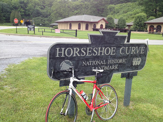
Horseshoe Curve

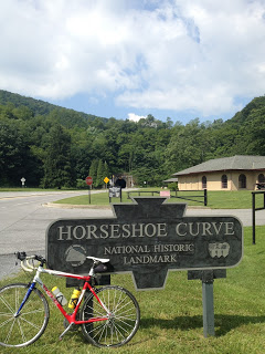
ALTOONA, PENNSYLVANIA

This is one of my favorite climbs. A four mile warm up climb followed by a four mile steep climb including an 18% wall. Three lakes and a 200′ tunnel. A mountain stream cascading down as you ride up. Trains creaking as they slowly make their way up the mountain. What more can one ask for?

On my way back from Ride the Rockies I never gave it thought that riding at altitude would help. This wasn’t a test to see if riding at altitude would make me stronger. If it was, it failed. 

I always underestimate how difficult the climb is. Today was no different. It is hard. But once to the top you have a couple miles of flat on top of the mountain followed by a nice seven mile descent on Sugar Run Road. For me it’s just a perfect place to ride.

Bats in the Belfry

ALTOONA, PENNSYLVANIA

Yesterday, on my way from Virginia to Punxsutawney, Pa., for a wedding, I stopped at the Logan Valley Mall for a “quick” ride up the mountain. I always love the climb and it’s always just enough to make me wonder if I will have to dismount and walk.

A wonderful surprise was new blacktop. This is so much better than three years ago when in September they put down a chip and tar surface. It was treacherous descending in all that loose gravel. But today was fresh blacktop. Sweet!

A bit chilly, 66 degrees, and I could have used arm warmers at the top, but didn’t have time to contemplate my choice. At the top I rode one mile to make sure I had 10 miles in so I could hit 20 on the round trip. Then I decided that it was shorter going back to turn around and ride that great black top than to continue over to Sugar Run Road. I don’t know if it was or not.

Beautiful road surface and still going UP
Glenwhite Road
But I had a nice descent. It was 55 minutes up and 16 minutes down.
I was able to come back today. For more.
Mid 50s and overcast at the start. Wheels down at 10:00 a.m. with a forecast of 70% chance of rain by 1:00 p.m. I wasn’t sure that I would want to do the long route (70 miles) that I planned and would play it by ear.
My Garmin was finicky. Although I had mapped out a “Three Church Ride,” it seemingly wasn’t calling out the turns for me so I was left to guess. Instead of climbing to the top of Frankstown Road via some neighborhood streets I found Garmin routing me around the mountain. Maybe it was smarter than me after all.

Canoe Creek Church
I rode out Scotch Valley Road and followed the signs to Canoe Creek State Park. Seeing an old church and cemetery I almost kept pedaling but the building next door, a garage, caught my eye with its handicapped parking. Out in the country, a country garage, and there was a handicapped spot.
That didn’t make a lot of sense to me unless this was a location people came to. And it was.

The church was the former Canoe Creek United Methodist Church.

In 1958 my father followed his calling to enter the ministry and as a student pastor was assigned to East Freedom with a three church charge. Canoe Creek, then Evangelical United Brethren Church (E.U.B.), was one of those three churches.

No longer an active church, it has been taken over by up to 20,000 bats. And people come here in the evenings to watch the bats.

Getting back on the road I saw a couple of cyclists go through the intersection I was approaching. After turning back onto Scotch Valley road I could see four cyclists riding about 300 meters in front of me. I tried to bridge to them.
As the line of four went up a hill, I caught them as one, Sean, who was on his first ride coming off shoulder surgery, was dropping back. We briefly continued as four and I wondered how long it would be before they realized they had four but it wasn’t the same four.
Sean and Anna
I started rolling with them then introduced myself. All kitted up in green of the Spokes N Skis shop, I met Bryan, Anna, Richard, and Sean.* Finding myself next to Anna I asked her how far they were going and she said they were 10 miles into a 30-mile loop returning to Hollidaysburg.

Perfect. For me.

I decided to ride with them and they were great hosts. They showed me the foot of Locke Mountain Road while we stayed in the valley. Bryan offered to show me the roads to my mapped out route but I told him the roads will always be here – I’d rather stay with the riders today. And we did.
Bryan
Bryan and I chatted, as did Rich and I, and I told them how much I love riding in Altoona. I even reminisced about riding three years ago while battling cancer. Although at first I couldn’t remember all the names, I mentioned the Stacy as one of the riders I met. Joel and Richard were the other two riders. Bryan couldn’t recall a Stacy.

Our formal ride of four, or five to include me, ended at Hollidaysburg. I said goodbye to Bryan and Anna, who will be married on September 15, then Richard and I pedaled on towards Altoona. Once back at the Mall where I parked I decided I could squeeze in a mountain ride too and headed up Sugar Run Road for another 19 miles.

Richard and Anna
On my descent down the new blacktop of Glenwhite Road, I hit 48.5 mph but was disappointed I did not reach 50 mph. This one is a little tricky. You can fly coming down off the Wall but there is a curve of which you cannot see the transition. The mind says to brake but I have been through this before and know I can lean through it.
I braked.
Just a touch. But that was just enough I’m sure to keep me from doing 50. I have to try again.

___
*Bryan Caporuscio, Anna Gauriloff, and Richard Fiore.

EPILOGUE – After returning home, Bryan remembered Stacy — Richard’s wife. He liked that I love the roads around Altoona and that I love to ride. He also stated that Stacy always wondered what happened to that guy with cancer who encouraged her while climbing up the wall in August, 2009, and was quite please I joined their group ride.

Peace on a Bike – II

ALTOONA, PA

Even in “winter,” the climb up Glenwhite Road from Horseshoe Curve is beautiful. There are enough Mountain Laurels that the forest retains a healthy look of green. A white water stream follows much of the road. From the time I turned onto Kittanning Point Road only two cars passed by on the next seven miles. I find it so peaceful riding here and it was a great place to come the day before surgery.

I created a 62 mile (100 km) ride and downloaded it to my bike’s Garmin. When I parked at Logan Valley Mall in Altoona and went to retrieve the route – it was gone. I must have screwed it up. More importantly, that meant I didn’t know where I was headed except up the mountain and I would improvise after that.

When I turned onto Kittanning Point Road I could hear a train above me, struggling to get up the mountain – the wheels creaking under the weight of the load. For a while I was “racing” the train to get to Horseshoe Curve. I smiled when I saw it ahead of me on the curve.

Passing by the Visitors’ Center, I was surprised that Horseshoe Curve was closed for the season. The trains still go by. And so did this cyclist although I did not see a single other cyclist today.

The climb up the mountain was harder than I remembered. I once went up it sitting down and briefly thought that would be today’s goal. Then it was a matter of just getting up it without stopping.

At the top I made it to Gallitzin but did not find the road to Cresson. I ended up at the entrance to the Allegheny Portage Railroad. From here, US Rte 22, the quickest way to Cresson, is a limited access divided four lane road off limits to my bike. I had to slip around the barriers and cut through the park on an access road to Old Rte 22 – Admiral Peary Hwy. I was comfortable cutting through the park even with the barriers in place because I park employee once told me to do that – that’s it’s OK for cyclists to use the access road.

Admiral Peary Highway in Cresson, Pa.

Admiral Robert Peary was an explorer who claimed to have led the first expedition, on April 6, 1909, to reach the geographic North Pole. He was from Cresson. Admiral Peary Highway, from Cresson to Ebensburg is a two lane shoulderless road with almost no flat sections. It’s either descending or climbing. It’s not my favorite road as there is a fair amount of traffic although there was no road rage on this day.

Mount Aloysius College, Cresson, Pa.

Once in Ebensburg, I saw a sign for a Bike Route and thought it was a less traveled road parallel to the main street. Instead it led me to the Ghost Town Trail — a nice rail trail but not suitable for a long ride on a road bike with its crushed limestone base. I rode it for 200 yards then jumped back on the road.

Ebensburg, Pa.
Notice above the red car Christmas decorations are still on the poles.

After Ebensburg I was winging it. I saw Alley Buck Road and remembered seeing that on a map it but didn’t see that it was also Beulah Road going in the opposite direction towards Nanty Glo. After a mile of headed the wrong way and sensing it – I found a man in his yard and asked for directions. He told me to turn around and go back to where I came from. I didn’t know if that was helpful or a warning. A cousin once warned me that the people around here are “rough.”

Ghost Town Trail, Ebensburg, Pa.

I crossed US 422 and headed north — until that didn’t feel right anymore. So I turned south. I didn’t realize that I had come to the town of Colver. I guess I was expecting more. There I asked a father and son for directions to Loretto.

At first they said go to Ebensburg and get on 22. I reminded them that I was on a bike. Then they suggested Peary Hwy. I then told them I needed to take back roads – the most direct route. So they sent me to Carrolltown.

In Carrolltown I was flying down a country road which felt right. Still, as I passed a house and saw a man in his garage I decided to stop. I told him how far I had traveled (50 miles) and that I was headed to Loretto then Gallitzin. He told me that the road would take me to “Loretta (sp).” Yikes, I wondered if we were talking about the same place.

Outside of Loretto/Loretta I stopped a car at a stop sign to make sure I was on the right road. I was.

Loretto, Pa.

In Loretto I talked to a couple about the next leg. Gallitzin. And they say that men don’t ask for directions.

On the road to Gallitzin I saw a mileage sign for “Gallitzin 3.” Then I came to a T and saw a sign “Ashville (left), Cresson (right).” There was no mention to the direction of Gallitzin. Love the Pennsylvania road signs. By feel, I was getting ready to turn right when a car pulled up. I asked directions. And right was correct.

That would begin the last three mile climb of the day, perhaps the hardest, if for no other reason I already had 65 miles in my legs. The last mile in Gallitzin was tough. Narrow steep streets, still with the gravel of winter on them. I didn’t think I would make the last two blocks. Knee hurting, I pushed through.

It’s hard to judge effort and the torn meniscus added pain or robbed me of power but the only other time I felt I would not make a climb was my first time up Mount Washington. I looked for a place to unclip and put a foot down but each pedal stroke got me closer to the top. And then it was a matter of a seven mile descent.

Garmin says my average cadence was 77 rpm. That seems high given all the climbing and lots of coasting, although I didn’t get in a tuck and not pedal nearly as much as one may think. But that’s more than 25,000 turns of the pedals. And every one hurt.

Knee Surgery Tomorrow

Surgery tomorrow. But peace on the bike today.

Peace on a Bike

ALTOONA, PENNSYLVANIA

For five months I looked forward to this day – the day that I would be back on the bike and come back to these mountains.

Much of 2009 was a blur with an illness and then a diagnosis of cancer. Most waking hours were spent thinking of cancer and quite a few sleeping moments as well. The only time I was completely at peace was on my bike.

I came to these mountains to enjoy their beauty and to getaway. Generally, when I was on my bike I thought of nothing else except riding. It was especially so when I was in the mountains.

I rode “The Wall” by Horseshoe Curve four times last year. I also went to the White Mountains in New Hampshire and was able to lose myself in thought. Truly, I found peace on my bike and in the mountains.

David Vito

We loaded up six riders in Reston, Va., at 7:00 a.m. and drove to Altoona, arriving by 10:30 a.m. It was “wheels down” at 11:00 and we headed out to Frankstown Road. We were greeted by an unexpected one and one half mile climb.

I had promised three great climbs and three screaming descents on my planned 100 km route. As we waited at the top of the hill – this was a no-drop ride – I had to rethink the 100 km route as everyone complained about not being in riding shape. I adjusted.

Kelly Noonan

Adjustment number one was we turned at Newry and started an 11 mile climb but at 2-3%, up to Puzzletown. In Puzzletown we turned on Valley Forge Road. Here I hit 48 mph – pleased, but then disappointed that I couldn’t push it to 50 mph.

Scott Scudamore leading the group up Valley Forge Road

We turned on Old U.S. 22 and began the seven mile climb to the top of the mountain. Once at the stone arch, we went through the Portage Railroad National Park and cut over to Gallitzin for a short break at a country store.

Then we earned our seven mile descent down Sugar Run Road. Three of us formed a paceline while the other three were content to ride it at a more reasonable speed.

At the bottom, we made our way over to Horseshoe Curve and split our group. A bit of a mutiny as Kelly Noonan and David Vito decided to sit out yet another climb, the steepest of the day too. The early season “big ride” was perhaps too much. But we pushed on.

David Vito at the base of Sugar Run Road

I was only disappointed as this was the climb I wanted everyone to experience. Although I was saving the best for last, perhaps we should have gone up this climb first. But we got everyone up and over the top, back to Gallitzin and down Sugar Run Road again. Then we made our way back to the van.

Kelly, David, and Vince at the bottom of Sugar Run Road

In a recovery that is slower than I want, I can say this was the best day I have had since surgery. I really needed this day.

As for peace on a bike, Kelley remarked to me that riding in Altoona one can only think of the suffering on the climb or the fear of descending at breakneck speed. “No wonder you never thought of cancer while you rode here.”

Indeed. Just peace on a bike.


Last Day in the Mountains

My early season riding began with a climb to the top of Blue Knob Ski Resort and included back-to-back weekends in August climbing Horseshoe Curve’s 18% “wall.” It is simply one of my favorite places to ride. But my cancer diagnosis made these mountains even more special. It was here where I could get away from cancer and find peace on my bike.
 
With Fall approaching and my season hitting the “wall” quicker than when climbing it, I took the opportunity to go to East Freedom, Pa. for one last ride in the mountains as I fully fight this cancer battle.

Statue of Liberty at Blue Knob

My ride took me up Pa. Rte 164 to the crossroads at Blue Knob. This was a seven-mile climb with long sections of 8% grade. It is a two-lane road with no shoulder but not heavily traveled either. And every single car gave me a wide berth when passing.
 
At the summit, I found a taste of New York. Their very own Statue of Liberty. Who knew?

14% Grade

I spotted a sign — “14% grade (next) 7 miles.” It was heaven! Nowhere can I find an equivalent grade to Mount Washington — 7.6 miles at 12% average. But this held promise. At last, a training ground for Mount Washington.

I braced for my descent because 14% can be quite dangerous on a bike. But it wasn’t to be. By my calculation, there may have been a section that was 10% but it didn’t last long. And it soon flattened out. Who makes these road signs anyhow? It was just a tease.

Also by my calculation, and my gut feel on the bike, from Blue Knob to Puzzletown was 4.5 miles at a 5% grade.

Allegheny Portage Railroad

From Puzzletown (can anyone figure out what they do there?) I traveled Valley Forge Road and found a sign for a 12% downgrade was close to an actual 12% which led to a 12% climb. Or more. But only for a mile down and a mile back up.

On Valley Forge Road

Reaching Old U.S. 22 I had a 5½ mile climb to the summit. For much of the climb, there were two lanes upward, divided, which meant that cars could easily move to the left lane to avoid getting too close to me. I rode on the right side of the white line but for a long stretch, there was very little shoulder. Yet more often than not cars gave me no berth and two idiots honked their horns at me like there was somewhere I could go. Into the woods, perhaps.
 
For about 30 minutes my mind was playing games trying to analyze why most drivers on a two-lane road would give me wide berth and cross into the oncoming lane and these drivers wouldn’t move over to the empty lane that was going in the same direction. Old US 22 would be used mostly by locals — locals who may believe it was faster and should remain faster than getting on the new US 22. Locals who believe the road belongs just to them. I just don’t know. Maybe people are jerks. A revelation.

Allegheny Portage Railroad

I never visited the Allegheny Portage Railroad Historic Site and always wanted to. And today I could. I am always intrigued by old-time engineering marvels and this was one of them.

Allegheny Portage Railroad – Lemon House

Operating from 1834 to 1854 it was built to carry barges from Johnstown to Hollidaysburg which connected river traffic between the Ohio and Susquehanna Rivers. It consisted of 10 inclined planes (think of the Inclined Plane in Johnstown or the Duquesne or Monongahela inclines in Pittsburgh).

Allegheny Portage Railroad – Incline Number 6

At the summit I was looking for a road over to Gallitzin but never found one. I saw a truck with U.S. Government Plates and stopped it and asked for directions to Tunnelhill. When I balked at the park ranger’s first suggestion, riding on U.S. 22, she told me to cut through the Allegheny Portage Railroad Park. Even though it was gated, she assured me that I could and I was surprised at the site and delighted in that it did take me to Tunnelhill Street.

I was glad I did. I would have never seen the Lemon house, other than from the road, or the tracks of Incline Number 6.

In Gallitzin, I met a local who encouraged me to go to the Gallitzin tunnels. He didn’t tell me the road to them was straight down. But it was. One can stand on a bridge and see the trains coming through the mountain. I wonder what’s it’s like to live above the tunnel?

Imagine living above a train tunnel

The climb back up to Tunnelhill Street was a neat 14-16% grade. But at 27 miles, that would be the last real climbing of the day.
 
From Gallitzin, it was a straight shot down Horseshoe Curve Road (Glenwhite Road) past the famous landmark and three reservoirs.

Horseshoe Curve

I’m not complaining because every ride up Horseshoe Curve is a good ride but who the heck thought of a process called chip and tar? The descent down to Horseshoe Curve can be screaming, especially when coming down off The Wall but the upper portion of this road had recently been chipped. Or tarred. Maybe just chipped. Without tar.

A 4-mile climb to the summit, sections of 18% grade and a 200′ tunnel. Life doesn’t get any better than this.

There were no line markings. Descending was tricky because with the loose gravel, er, I mean “chips,” one could easily slide out. Once I got to the good pavement I could let it roll.

Because of mine drainage, there are channels to keep the acid water out of the reservoirs

The rest of the ride was simple exploring as was all but the Gallitzin to Horseshoe Curve portion. I wrote down some simple directions and followed those but was unsure when I was in Hollidaysburg where I should travel to next. There was a service station with a store and I needed to replenish my water.
 
I walked into the convenience store and it reeked of cigarette smoke. All I could see was shelves of cigarettes and chewing tobacco. I turned to the sales clerk and asked “do you sell anything healthy in here?” I’m a jerk.
 
When she asked what I meant I simply asked for water. Outside was a visibly pregnant mother smoking, waiting with the dog while her husband bought more cigarettes. I wanted to scream at her “GIVE YOUR CHILD A CHANCE!” But would good would have it done? I am reminded that this is still Appalachia and a cyclist with shaved legs wearing Lycra is the stranger here.

Actually a very steep portion of Glenwhite Road

I will miss riding in Altoona. Each of my trips involved meeting special people. On the first, I met John Griffin who lives in a house where I lived 50 years ago. He invited me in. On the second and third I met and rode with riders from Spokes and SkisJoel, Richard, Bryan, and Stacey. Also there was Stephanie from Panera. And today I had a park employee let me cut through the park, a local send me to the tunnels, and two others point me in the right direction when I was unsure. Really unsure.
 
I’m afraid this is the end for a while. I have hit the wall.


Horseshoe Curve – The First Time

ALTOONA, PENNSYLVANIA

I was up early at my parent’s house in Friedens and decided to ride some more in the mountains. I drove to Jennerstown and parked on Main Street. I rode the mile or so out of town then the steep descent on U.S. Rte 30. After a quarter-mile drop, one is at the lowest point before the climb.

The Tour of Pennsylvania described this as a two-mile climb with a very intense mountain pass that sees grades of 15%. I had no problem going right up the mountain although not as fast as the boys did on Friday. I wanted to go over the top back to Laughingtown then come back up and over but the sky looked ominous. It looked like a storm was about to move into these mountains and I didn’t want to get caught in it. I turned around at the truck area and headed back to Jennerstown. I was disappointed that I never got above 45 mph on this descent.

I thought about driving over to Rector and going up, then down, Darlington Road again but wasn’t sure where the storm was and wanted to try something new. I drove to Altoona.

I had remembered an article Bicycling about the toughest 100 climbs in the U.S. One of those was the Horseshoe Curve climb in Altoona. I parked on 58th Street and started out towards Kittanning Point Road. The climb was up, past three reservoirs, but never very tough. As I climbed I heard a train creaking and breaking as it descended the Allegheny Mountains towards Altoona. It was way too easy that I reached Horseshoe Curve.
I couldn’t believe this was a tough climb. It wasn’t.

I saw a tunnel and went through it under the Horseshoe Curve. On the other side was a beautiful forested country road. I kept riding and it kept going up. And that was the new deal I made with myself. As long as the road turned up, I would keep riding.

My first trip up Horseshoe Curve
Tunnel at Horseshoe Curve

I saw a sign for Adopt a Highway and saw it was sponsored by Blair Co. Bicycle Club for the next four miles. I figured I had four miles. Cool.

After about three more miles I was getting tired. I was in my granny gear and was standing and sweating. But I kept moving without “paperboying” back and forth across the road to make the grade a little easier. Finally, it became easier.

I read later that this section is 10-12% but then one hits the wall at a 19% grade for a half mile before settling back to 12% for the last mile. That was it. And I made it. I love riding in these mountains.

I turned around. On the descent, I wanted to let it out. But this road had many curves and it was raining. The rain was following me. The last speed I saw was 43 mph in a curve. Then my computer went out. On the transmitter, a support broke off so it wasn’t in the right position to read the magnet on the spoke. I was doing 0 then 10 then 6 then 4 then 38.

I will need to come back and explore this more. Much more. It was everything as advertised especially “three lakes and a 200′ tunnel.” It is absolutely beautiful.

Verified by MonsterInsights